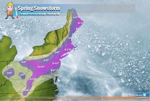
Spring had sprung, but Old Man Winter has decided to linger in the northeastern United States with yet another nor’easter. Each winter storm has its own nuances, and these eight are specific to this week’s storm:

#1: Very Heavy Snow
Snow will be very heavy at times on Wednesday, especially over southeastern Pennsylvania, central and southern New Jersey, Delaware, eastern Maryland, the New York City metro area, Long Island, Connecticut, Rhode Island, and southeastern Massachusetts. In this area, snow will fall at rates in excess of 1″/hour; some exceptionally heavy snowfall of 3″/hour cannot be ruled out. These heavy snowfall rates will lead to white-out conditions with zero visibility at times. Travel will become difficult if not impossible during the day in these heavy snow bands; avoid travel if possible. The heavy snow will taper off from southwest to northeast across the Mid Atlantic on Wednesday night while the snow will wrap up from southwest to northeast across northern and central New England by Thursday morning.

#2: Strong Winds
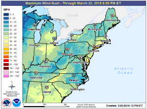
As the area of low pressure deepens rapidly off the Mid Atlantic coast, winds will pick up. Wind gusts will be 20-40mph inland and 30-50mph at the coast. The wind alone may cause some damage, especially to trees and power lines weakened by previous nor’easters this month. The worst winds will strike during the afternoon and evening hours on Wednesday; breezy conditions will linger into Thursday as the storm slowly pulls out to the north and east.
#3: Wet Snow
Throughout much of the storm, most snow will be of the heavy, wet variety that will likely stick to as many surfaces as it can. Great for making snowballs or snowmen, this snow will also cling to tree limbs and wires, adding weight which could be enough to make either snap. Combined with gusty winds, expect significant, long-duration power outages during and after the storm. Due to the weakened infrastructure from past storms, it may take many days for power to be restored to some areas.
#4: Coastal Flooding
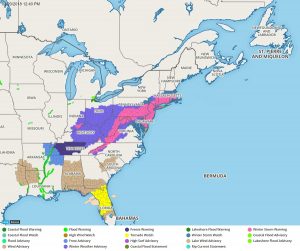
There will be moderate coastal flooding along the Jersey Shore and southeastern Massachusetts; coastal flooding is also possible around Long Island and Long Island Sound and Delaware beaches. Minor coastal flooding is possible along Delaware Bay and up the Delaware River. A storm surge of 2-3′ could inundate areas, especially those prone to coastal flooding. Surging waters, rough waves, and high winds will also batter the coastline, leading to beach erosion. People in areas prone to coastal flooding should plan to head to high ground before the worst of the storm arrives. Coastal flooding will build beginning today, will peak Wednesday, and will begin to diminish on Thursday.
#5: Thundersnow
Thunderstorms are likely to form during the peak of the storm on Wednesday; it appears the area most susceptible to thundersnowstorms is over southeastern Pennsylvania including the city of Philadelphia, central and southern New Jersey, the New York City metro area, and Long Island. Thunderstorms will drop exceptionally heavy snowfall over a short period of time, could contain gusty winds, and obviously have dangerous lightning. Remember: when thunder roars, head indoors; lightning can kill in any season. If thunder is close enough to hear, lightning is close enough to kill.

#6 Convective Banding
These convective bands, with thunderstorms, will feature exceptionally heavy snow amounts in the areas they set-up. These are extremely localized events that will produce much more snow than surrounding areas. In face, convective bands of snow will rob adjacent areas of their snow potential. As an example, if a convective band of snow sets-up over Freehold, NJ, Freehold could end up with several inches more snow than communities just east such as Englishtown, NJ and Jackson, NJ. If you see a convective band of heavy snow set-up to your east, expect your snow totals to be somewhat less. If you see a convective band of heavy snow set-up over your area, expect some of the heaviest snow totals where you are.
#7 Severe Weather
The northeast isn’t the only place to be impacted by today’s storm; the southeast will be hit hard too, albeit by severe thunderstorms and tornadoes rather than snow. The National Weather Service has issued a Tornado Watch for portions of Florida. Tornadoes became violent last night in the southeast and more of the same is expected through today and tonight. Residents in the Tornado Watch area should be on the look-out for severe weather and take immediate action should a Tornado Warning be issued. There may only be moments to act to save your life when a Tornado Warning is issued for your county.