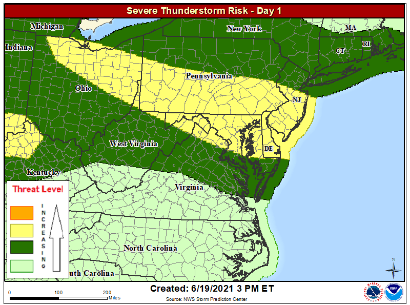
Severe thunderstorms and tropical storm conditions are possible from two unfolding weather events across the U.S. East Coast today into tomorrow and Monday. Damaging thunderstorm winds and isolated large hail are possible from portions of the central High Plains to the Mid-Atlantic. A tornado threat also exists over parts of the central Gulf Coast States to southwestern Georgia, east of the inland track of Tropical Storm Claudette. With Tropical Storm conditions possible along the East Coast, the National Hurricane Center now has a Tropical Storm Watch in effect for part of the coast now.
Beyond the impacts from Claudette happening on the Gulf coast right now, there is growing concern for a severe weather outbreak in portions of the Mid Atlantic this afternoon and evening. A shortwave trough over Lower Michigan this morning will help to initiate storms across northern Ohio now, with storms tracking southeastward through the evening. Other more isolated clusters of activity are expected from West Virginia into the Chesapeake Valley
this afternoon. All of these storms will pose some risk of locally damaging wind gusts and hail; there is also a slight risk of an isolated tornado or two.

Meanwhile, conditions continue to evolve as Tropical Storm Claudette moves inland across the southeastern United States. With the storm moving inland, the Tropical Storm Warning from the Mississippi/Alabama border to the Mouth of the Mississippi River has been discontinued. However, a Tropical Storm Warning remains in effect for the the area from the Mississippi/Alabama border to the Okaloosa/Walton County line in Florida. A Tropical Storm Watch is also now in effect for North Carolina from Cape Fear to Duck and for Pamlico and Albemarle Sounds. A Tropical Storm Warning means that tropical storm conditions are expected somewhere within the warning area. A Tropical Storm Watch means that tropical storm conditions are possible within the watch area, generally within 48 hours.
Claudette is moving toward the north-northeast near 14 mph. According to the National Hurricane Center, a turn toward the northeast is expected later today, followed by a motion toward the east-northeast tonight or Sunday. On the forecast track, the system should move farther inland across portions of the southeast U.S. through Sunday night, and over the western Atlantic Ocean on Monday.
Claudette’s maximum sustained winds are near 40 mph with higher gusts now. The National Hurricane Center says Claudette is expected to weaken to a tropical depression later today, but forecasts it to regain tropical storm status when it moves across the Carolinas Sunday night or
early Monday.
The estimated minimum central pressure based on surface observations is 1007 mb or 29.74″.
A variety of hazards are being produced by Claudette: flooding rains, damaging wind gusts, lingering storm surge flooding, and the threat for tornadoes.
Claudette is expected to produce rainfall totals of 5-10″ with isolated maximum amounts of 15″ across portions of coastal Mississippi and Alabama, and the western Florida Panhandle through the afternoon. Considerable flash, urban and small stream flooding impacts as well as new and renewed minor to isolated moderate river flooding are likely across these areas. As Claudette heads north and east this weekend, heavy rain will occur across central Alabama, central and northern Georgia, and into the Piedmont of the Carolinas, resulting in rainfall totals of 3-6″ with isolated maximum amounts of 8″. Flash, urban, small stream and isolated minor river flooding impacts are possible.
The combination of storm surge and the tide will cause normally dry areas near the coast to be flooded by rising waters moving inland from the shoreline. A storm surge of 2-3′ is possible from the Mississippi / Alabama border to the Okaloosa / Walton county line in Florida, as well as Mobile Bay. When Claudette heads to the Mid Atlantic, a storm surge of 1-3′ is possible from Cape Lookout, North Carolina north to the North Carolina / Virginia border. Surge-related flooding depends on the relative timing of the surge and the tidal cycle, and can vary greatly over short distances.
Tropical storm force winds should continue along the coast in the warning area for a couple of more hours. Tropical storm conditions are possible in the watch area on the East Coast Sunday night and Monday.
A few tornadoes are possible today and tonight across southeast Alabama, the western Florida Panhandle, and southwest Georgia as Claudette spins through.