After a day of isolated strong and severe thunderstorms and rain showers, the Mid Atlantic is dealing with yet another round today. Today’s showers and storms have more moisture to work with, prompting the National Weather Service to issue Flash Flood Watches and Warnings for the region.
Multiple rounds of showers and thunderstorms will be impacting this region today. The first round moved across portions of northeast Pennsylvania and northern and central New Jersey this morning as the first of several vorticity impulses moved across the area and interacted with the frontal boundary that is located across the northern Mid Atlantic. Ongoing embedded thunderstorms and
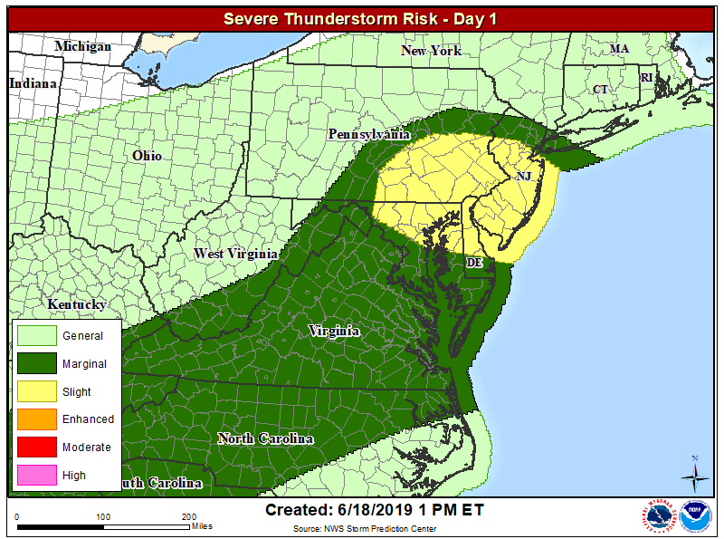
periods of moderate to heavy rain will occur for some areas today. The second round is moving into the region now as a surface low moves across the area along the stalled out boundary and another vorticity impulse moves across the area. This afternoon round has a better chance of thunderstorms to be associated with it. As some partial clearing develops from south to north, instability will develop through the day. This instability will allow the development of severe thunderstorms , with thunderstorms increasing in coverage and severity as the day continues. Because of that threat, the National Weather Service’s Storm Prediction Center has increased the odds for severe storms in their latest Convective Outlook for much of New Jersey and Delaware, eastern Pennsylvania, and northeastern Maryland.

Many of these showers and storms will be producing very heavy rain. In New Jersey, this heavy rain has prompted the National Weather Service to issue a Flash Flood Warning for portions of Mercer, Somerset, and Middlesex Counties today through at least 5:45pm. A short time ago, dopplerRADAR indicated thunderstorms producing heavy rain across the warned area. Up to one inch of rain had already fallen. Flash flooding is expected to begin shortly in the areas of heaviest rain. According to the National Weather Service, some locations that could experience flooding include the towns of New Brunswick, Somerset, Edison, Old Bridge, East Brunswick, South Brunswick, Sayreville, North Brunswick, Princeton, Matawan, Jamesburg, Hopewell, Rocky Hill, Skillman, Brownville, Kingston, Dayton, Plainsboro Center, North Brunswick Township, and Kendall Park. Additional rainfall amounts of one to two inches are possible in the warned area. The National Weather Service warns that most flood deaths occur in vehicles; they urge people to “turn around and don’t drown when encountering flooded roads.”
Elsewhere in the Mid Atlantic, excessive runoff from heavy rainfall will cause flooding of small creeks and streams, urban areas, highways, streets and underpasses as well as other drainage areas and low lying spots. The threat of strong to severe thunderstorms and soaking heavy rains will persist into the evening hours.
