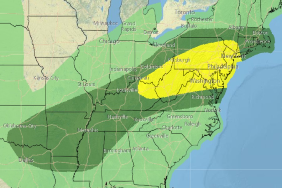
Severe thunderstorms and isolated tornadoes are possible in portions of the Mid Atlantic on Wednesday, with the greatest threat of tornadic cells over parts of New Jersey, Pennsylvania, West Virginia, and Ohio. Severe Thunderstorm or Tornado Watches or Warnings may be needed for these regions as thunderstorms fire up during the day.
According to the National Weather Service’s Storm Prediction Center (SPC), an upper trough will progress eastward on Wednesday from the Mid and Upper Mississippi Valley to the Northeast while a seasonally moist airmass will be in place across much of the Midwest to the Mid-Atlantic. The strong heating expected there will support moderate to strong destabilization of the atmosphere leading to thunderstorm and severe thunderstorm development.
The SPC says that forcing for ascent associated with the eastward-advancing upper trough and one or more mesoscale convective vortices moving across the region will support scattered to numerous strong and severe thunderstorms through the afternoon and evening hours.
One cluster of strong to severe thunderstorms is expected to be focused from Pennsylvania eastward into New Jersey and southern New York state ahead of a southward sagging cold front. Effective shear magnitudes here will support a few supercell and/or bowing structures.

The SPC believes that damaging wind gusts and isolated large hail will be the main hazards with this activity.
Another cluster of strong to severe storms is expected to develop over the higher terrain of eastern Kentucky and West Virginia along with northern Virginia. Vertical shear will be weaker with southward extent here, but deeper mixing with very steep lapse rates is noted in forecast soundings. As such, the SPC warns that damaging gusts and isolated hail will also be possible with this activity.
The SPC also warns that the potential may exist for higher severe probabilities in subsequent outlooks for portions of the Mid-Atlantic and Northeast if an organized bowing structure can develop.
