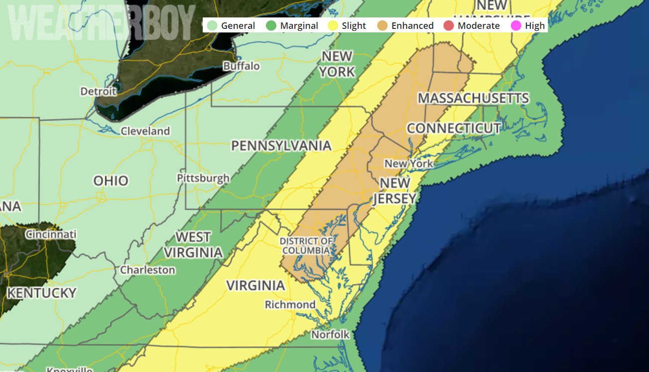
A severe weather outbreak is likely on Monday as a variety of ingredients conspire together to create the potential for severe thunderstorms and tornadoes. The greatest threat of severe weather is over eastern Pennsylvania, eastern New York, New Jersey, western Connecticut and Massachusetts, southern Vermont, central Maryland, and parts of northeastern Virginia. The cities of Philadelphia, Washington, DC, Albany, and Baltimore are in this enhanced severe weather threat zone. In their convective outlooks, the National Weather Service’s Storm Prediction Center outlines where the greatest threat of severe weather is; within the “Enhanced” zone, they believe numerous severe storms will be possible; such storms may be more persistent and/or widespread, and some may be very intense.
The National Weather Service defines a severe thunderstorm as a storm having these characteristics: has measured wind gusts up to or in excess of 58mph, and/or hail to at least 1″ in diameter, and/or spawns a tornado. A thunderstorm doesn’t need to be severe to be deadly; lightning and flash floods from even non-severe storms have claimed lives before.
Scattered strong to severe thunderstorms are possible across portions of the Northeast into the Mid-Atlantic states Monday afternoon into the early evening. Damaging wind gusts will be the primary severe hazard but large hail is also possible.
An upper-level trough will move across the Great Lakes and Ohio Valley on Monday as southwesterly mid-level flow remains over the Northeast. At the surface, a cold front will advance eastward across the lower Great Lakes and Ohio Valley. Ahead of this front, surface dewpoints in the mid to upper 60s should result in a corridor of moderate instability from the Carolinas north-northeastward into the Mid Atlantic. Thunderstorm development should take place along the front during the morning with a gradual expansion of convective coverage taking place in the afternoon. Several line segments may organize along the front moving to the coast of the Mid-Atlantic by early evening.
The type of set-up in the atmosphere that should exist tomorrow will support severe multicell line segments capable of producing damaging wind gusts. The faster moving short bowing line segments may produce longer swaths of wind damage mainly from Maryland north-northeastward into far southwest New England where the enhanced risk has been maintained. The potential for damaging wind gusts should be more isolated from central Virginia into western North Carolina where large-scale ascent is forecast to be considerably less than in areas to the north. Isolated large hail could also occur with the stronger updrafts along the front.
Anyone in the “Marginal”, “Slight”, or especially “Enhanced” zones should closely monitor the weather conditions on Monday and be prepared to take immediate action if life-threatening weather conditions materialize there. Before the dangerous storms arrive, residents throughout the Mid Atlantic should spend the relatively quiet day before the expected severe weather event to secure outdoor objects: toys, patio furniture, garbage cans, signs, and more can become airborne and dangerous flying projectiles in severe storms. With the threat of isolated tornadoes, residents should also know exactly where they and their loves ones should go should a tornado be spotted in their county.
