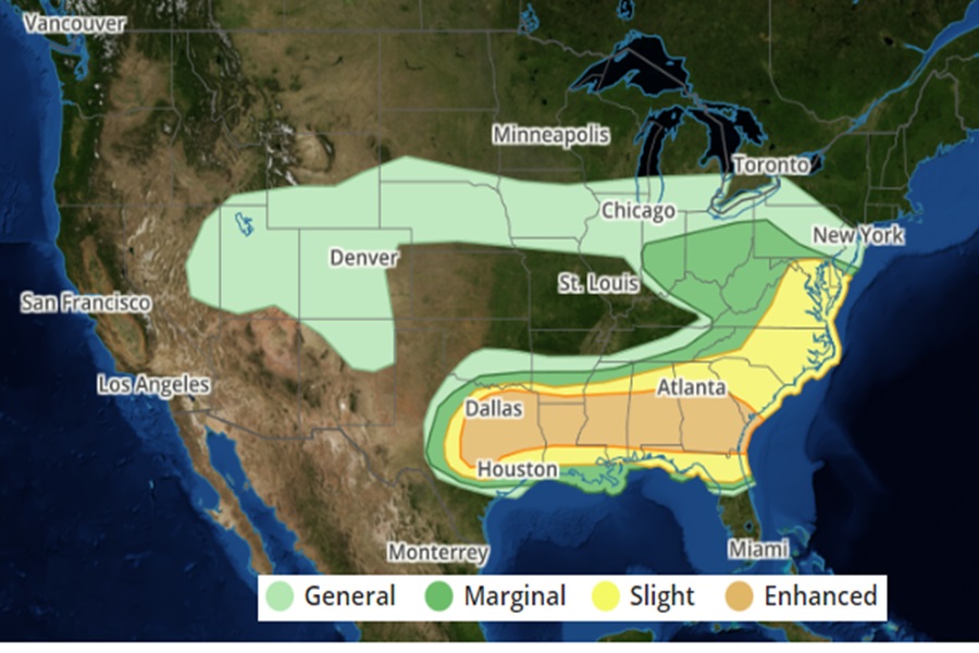
This week’s severe weather outbreak across the country will continue with an area of severe weather possible from southern New Jersey south to Florida and west to central Texas. The area between Dallas and Atlanta is at greatest risk of severe thunderstorms and tornadoes today; Austin, Texas, Jacksonville, Florida, Baltimore, Maryland, Charlotte, North Carolina, Washington DC, and Virginia Beach, Virginia are also at risk of seeing severe weather today.
Very large hail with multiple supercells appears probable across parts of central Texas into the ArkLaTex vicinity this afternoon and evening. A broader corridor of severe hail and damaging-wind potential will extend from east Texas into the lower Mississippi Valley and Southeast. According to meteorologists at the National Weather Service’s Storm Prediction Center (SPC), the main threat is expected along a generally west-to-east corridor from parts of north/central Texas into the Southeast. Some severe potential will persist across parts of Alabama and Georgia during the day, with at least some risk of all severe hazards.
Supercells capable of producing very large to giant hail and possibly a couple of tornadoes are possible across parts of central/north Texas during the afternoon and early evening. One or more fast-moving mesocyclone convective systems may move eastward across parts of the Southeast tonight, potentially producing a swath of damaging wind.
There will be more severe weather tomorrow, although across a much smaller area. The threat of severe storms on Friday will stretch from southern Alabama and Mississippi into central and southern Georgia and South Carolina and southern North Carolina and central Florida. The greatest threat of severe storms tomorrow will be in an area across northeastern Florida to southeastern South Carolina including much of southern Georgia.