Unfortunately for those planning to hit the polls, it appears severe weather will strike in the Mid Atlantic in time for the 2018 Election Day. A few severe storms with damaging wind gusts and perhaps a tornado or two will be possible from the Carolinas into the Mid Atlantic on Tuesday.
Responsible for tomorrow’s severe weather chances is a low pressure system moving through the southeast today. Today, the system will bring a good chance of severe thunderstorms across portions of the deep south, with the core of bad weather expected over Tennessee, northern Mississippi and Alabama, and eastern Missouri. This weather maker will head to the Mid Atlantic tomorrow.
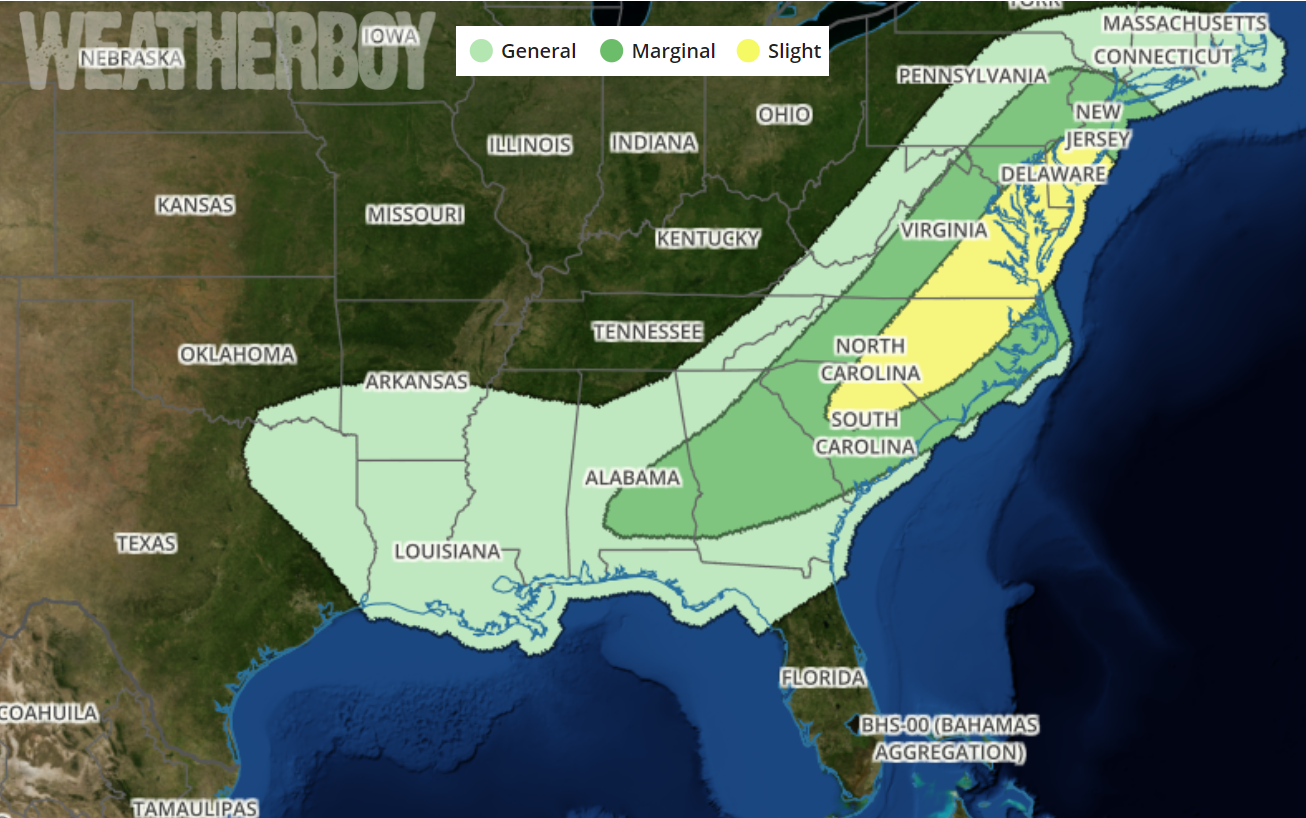
The greatest threat for severe weather on Election Day will stretch from central New Jersey south along the I-95 corridor into central South Carolina; portions of Delaware, Maryland, Virginia, and North Carolina are included in this area.
A negatively-tilted upper-level trough will move northeastward into the Northeast on Tuesday as southwest mid-level flow remains over the Carolinas and Mid-Atlantic. At the surface, a cold front will advance quickly eastward across the central and southern Appalachians Tuesday morning and into the Appalachian foothills Tuesday afternoon. Strong large-scale ascent along the upper-level trough and enhanced low-level convergence along and ahead of the front will support a convective line ongoing at daybreak in the southern and central Appalachians. This line should be in a decaying state as it moves over the Appalachian crest early in the day. A marginal wind damage threat will be possible along the frontal wind shift especially if a line of weak convection can remain in tact Tuesday morning. As the front moves into the foothills of the Appalachians Tuesday afternoon, convection is likely to develop from southeastern Virginia south-southwestward into central North Carolina and central South Carolina. This convection should intensify and may become organized as it moves east-southeastward into the lower elevations.
By midday on Tuesday, a moist airmass will be in place ahead of the front across most of the Carolinas into the eastern third of Virginia where surface dewpoints should be in the mid to upper 60s. Although a low-level flow will weaken steadily during the afternoon as the upper-level trough pulls away, moderate deep-layer shear along with wind vectors parallel to the front will favor the development of an organized line. The line should have a wind damage threat along the leading edge. An isolated tornado threat will also be possible with rotating cells embedded in the line. The wind damage threat is forecast to persist into the mid to late afternoon as the line moves eastward to the coast of Virginia and into east-central North Carolina and central South Carolina.
Further to the southwest into central Georgia and southeastern Alabama, deep-layer shear is forecast to be considerably weaker. In spite of this, steep low-level lapse rates and instability ahead of the front should be enough for a marginal wind damage threat during the afternoon.
After dark, the severe threat will quickly diminish. By Wednesday, the National Weather Service’s Storm Prediction Center believes there will no longer be a threat of widespread severe thunderstorms anywhere in the country.
