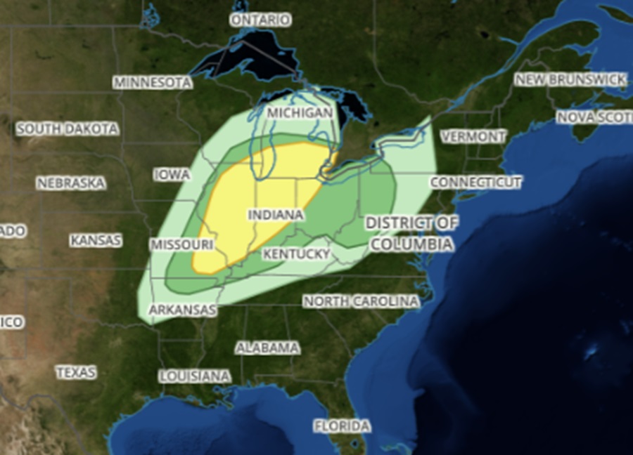
A severe weather event is likely to unfold on Tuesday across portions of the Ohio Valley. Within this area, there is also an elevated risk of tornadic thunderstorms. The National Weather Service is encouraging people to prepare for this severe weather outbreak.
According to the National Weather Service’s Storm Prediction Center (SPC), scattered strong to severe thunderstorms, associated with large hail, some near 2″ in diameter, damaging gusts, and a few tornadoes will be possible from late Tuesday afternoon, into the evening and overnight from parts of the mid Mississippi Valley to the Ohio Valley and southern Lower Michigan.
The SPC says that the upper atmospheric weather pattern is forecast to feature a northern-stream shortwave trough over the northern Rockies early Tuesday morning. At the same time, moderate to strong southwesterly flow within the southern stream will extend from off the Baja coast into the Mid-South. The overall upper pattern will trend toward consolidation as the northern-stream shortwave progresses eastward and evolves into a full latitude trough covering much of the central US by Wednesday morning. A surface low associated with this trough is expected to deepen as it moves across the Upper Midwest and Upper Great Lakes.
“A fast-moving cold front attendant to the deepening surface low will progress quickly eastward/southeastward across the Plains and Mississippi and Ohio Valleys, with thunderstorms anticipated as it interacts with the returning low-level moisture,” the SPC wrote in their latest Convective Outlook.
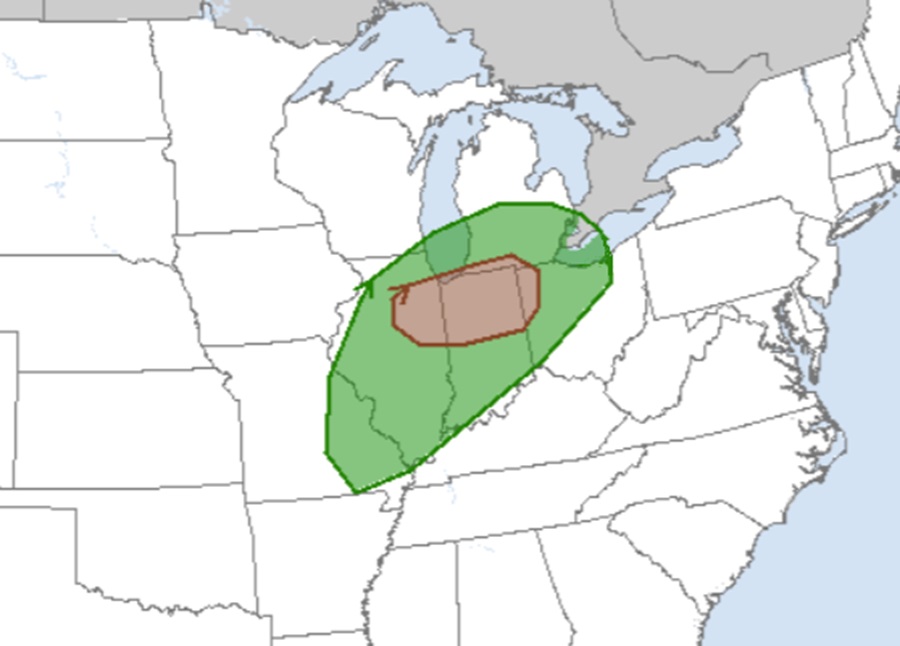
The activity could become violent over the upper Ohio Valley on Tuesday. Showers and thunderstorms will likely be ongoing over eastern Ohio, supported by moderate low-level southwesterly flow and associated warm-air advection regime. Cold mid-level temperatures and attendant steep mid-level lapse rates will support enough buoyancy for deep updrafts, with moderate deep-layer vertical shear contributing to some potential for updraft organization and rotation. As a result of this atmospheric action, some of these thunderstorms may become strong enough to produce large hail too.
During the afternoon hours, the airmass across the region is expected to gradually destabilize throughout the day amid a combination of increasing low-level moisture and cooling mid-level temperatures. “The highest storm coverage is anticipated north of the warm front, with steep mid-level lapse rates and strong vertical shear supporting robust updrafts capable of large to very large hail within these elevated storms,” the SPC warns, adding that, “Backed low-level flow is also possible in these areas, resulting in the potential for supercells capable of all severe hazards, including tornadoes.”
While the duration and coverage of early evening storms may impact thermodynamics, the general expectation is for another round of thunderstorms to develop along the cold front as it moves through. As the evening continues, storm intensity will lessen as will the coverage area of storms. More severe weather could fire up to the east of this activity on Wednesday, but the atmospheric dynamics won’t nearly be as strong and as dynamic as they’re expected to be on Tuesday.
