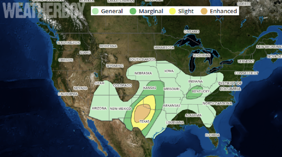
Beyond today’s strong to severe thunderstorms that impacted portions of the Plains today, it appears more storms are expected to fire-up over a broader area on Wednesday. Scattered severe thunderstorms are expected mainly Wednesday evening into the overnight across parts of the southern and central Plains. Damaging winds, large hail and a few tornadoes are possible. Some strong to severe storms may also form over the lower Ohio Valley, producing strong wind gusts. This stormy weather will then push east for Thursday.
A storm system moving across the country is responsible for the rough weather. An upper level shortwave trough will eject northeast from northwest Mexico to the southern and central Plains on Wednesday. A weak area of high pressure at the higher levels of the atmosphere will exist ahead of this storm system over the southern Plains. At the surface, an area of low pressure will develop over eastern Colorado and head east into Kansas overnight. With this kind of set-up, thunderstorms will develop along a dryline that’ll exist over western Texas, initially introducing a hail and strong wind threat there. With time, thunderstorms will increase in intensity and coverage into the evening hours; they’ll also expand east with time.
According to the National Weather Service’s Storm Prediction Center, the thermodynamic and shear environment will support both supercells and bowing segments as the thunderstorms blossom. More discrete convection will pose a large hail threat, and if surface based, damaging winds and a few tornadoes will be possible. Convection will spread northeast with time through the nighttime and early morning hours, with a continued threat of all severe hazards shifting east the next day.
Even with precautions in place due to the COVID-19 Pandemic, people need to be weather-aware and storm-ready should Severe Thunderstorm or Tornado Watches/Warnings be issued. Before the threat arrives, people should develop a plan for where they would take cover regardless if they’re in home, in quarantine, or sheltering in place.