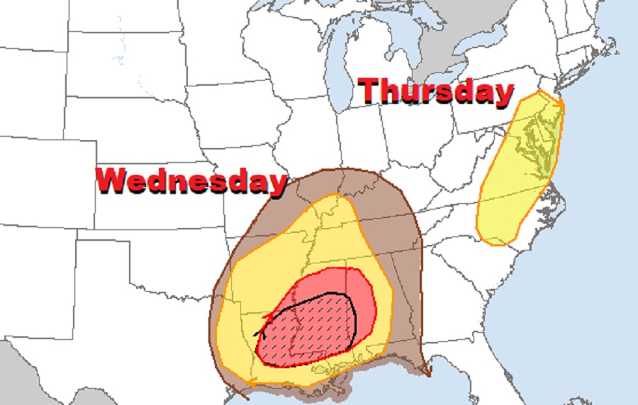
A severe weather outbreak is expected to unfold Wednesday and Thursday across portions of the eastern United States, with destructive winds and strong tornadoes likely. To get the word out about the severe weather threat, the National Weather Service’s Storm Prediction Center (SPC) has updated their Convective Outlook to show threats expected on Wednesday and Thursday. Yesterday, the SPC took the unusual step of including portions of the Mid Atlantic in their Day 5 outlook, something the agency hasn’t done in March for the area this far out for as far as records have been kept in 2009.
“Thunderstorms capable of severe wind gusts and tornadoes are expected across much of the Lower / Middle Mississippi Valley and Southeast,” the SPC warns in their latest Convective Outlook about this severe weather outbreak. According to the SPC’s analysis, a strong southern-stream shortwave trough is forecast to extend from central Kansas through the Texas Hill Country early Wednesday morning. This shortwave is expected to progress eastward and northeastward throughout the day, becoming increasingly negatively tilted as it does. Strong mid-level flow will accompany this through, with potent winds stretching from southeast Texas northeastward through the Mid-South Wednesday afternoon.
Due to the energy and wind available to the system, a convective line should be ongoing Wednesday morning, likely extending from the Ozark Plateau southwestward across eastern Oklahoma into northeast Texas. This line is forecast to move eastward throughout the day, forced by the strong ascent attendant to the shortwave trough. Even with marginal atmospheric conditions early, the SPC expects an invigoration or intensification of the convective line as it moves eastward into the Lower Mississippi Valley through the day. Here, the primary threat within the line will be strong gusts although embedded tornadoes are possible too. The potential also exists for a well-organized convective line capable of significant wind gusts in excess of 74 mph; as such, people should be on alert for a possible derecho.
The SPC says that while the kinematic profiles “certainly support long-lived supercells capable of strong tornadoes”, whether or not they actually form remains questionable. Because this convective line is moving quick which would limit severe weather development within the storm’s warm sector, while tornadoes will be likely, confidence in the formation of long-track strong tornadoes isn’t high yet.
For Wednesday, the greatest concern for severe weather is over portions of Louisiana, Alabama, and Mississippi. On Thursday, the greatest concern moves to New Jersey, Pennsylvania, Delaware, Maryland, Virginia, and North Carolina.
By Thursday morning, broad cyclonic flow is expected to be in place across the United States. Several shortwave troughs will be embedded within this larger upper trough, with the lead wave expected to move from the upper Ohio Valley northeastward through the Mid-Atlantic and Northeast early during the day. According to the SPC, another wave will follow quickly in the wake of the first, moving across the Ohio Valley and Mid-Atlantic regions. The evolution of this second wave will encourage the eastward progression of a cold front through the Mid-Atlantic; with modest buoyancy forecast for the atmosphere and very strong wind fields blowing overhead, the potential for damaging wind gusts with storms along and ahead of this front are likely. Isolated tornadoes cannot be ruled out, but most of Thursday’s severe weather threat should be from damaging straight-line wind in and around those storms.
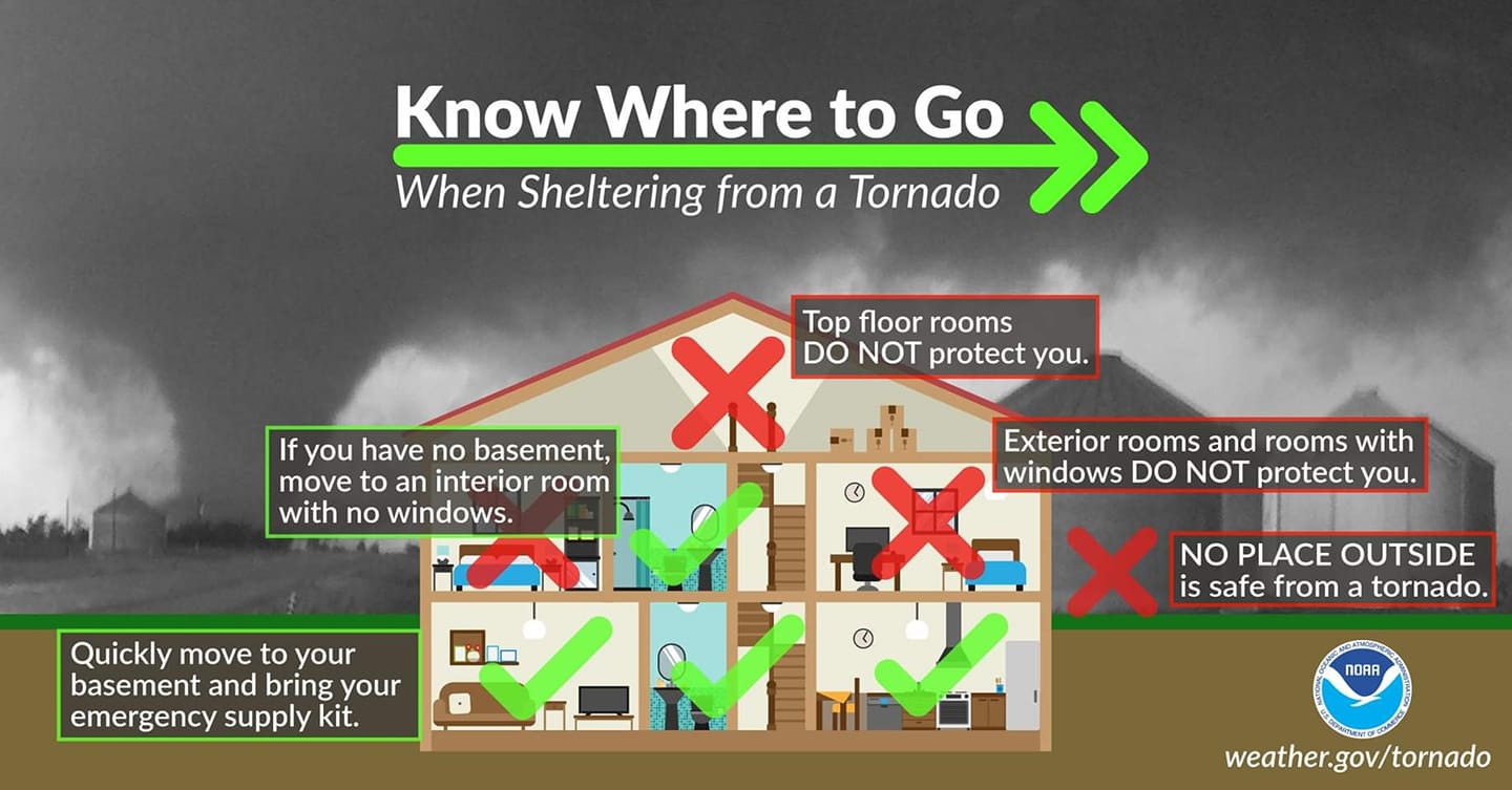
For now, people in the areas of concern should prepare for the arrival of severe weather. Securing outdoor objects should be the first priority: garbage cans, children’s toys, election signs, and spring decorations could become dangerous in the air should strong winds or tornadoes strike. Before the storm threats arrive on Wednesday and Thursday, people should make sure they can get and receive severe weather alerts from the National Weather Service and be ready to take immediate action should a Tornado Warning or Severe Thunderstorm Warning be issued for their area.
