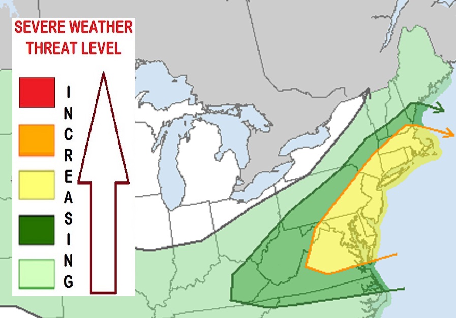
A severe weather outbreak is likely for the I-95 corridor from the Washington, DC metro area north through Baltimore, Philadelphia, New York, Hartford, Providence, and on to Boston on Monday, with damaging winds, large hail, and isolated tornadoes possible again. While scattered thunderstorms will be likely from central Virginia north to western Maine, the greatest threat of severe weather will be around the I-95 corridor. According to the National Weather Service’s Storm Prediction Center (SPC), damaging wind gusts will be the primary severe weather hazard in Monday’s forecast outbreak.
Meteorologically, a broadly cyclonic mid-level flow will exist across the northern continental U.S. on Monday as an upper-level anticyclone remains established across the south-central United States. A cold front will move east off of the northeast U.S. coast late Monday and extend west from the mid-Atlantic across the Tennessee Valley and the central Plains. This cold front passage will be responsible for triggering severe weather.
According to the SPC, a very moist air mass will exist in advance of the cold front Monday with surface dew points in the uncomfortable 70’s and precipitable water values near 2″. Southwest to west mid-level flow will result in deep-layer shear over the Delmarva Peninsula and across much of the northeast. Frontal convergence and diurnal heating will contribute to thunderstorm development along the front by afternoon, with multicell clusters or line segments capable of mainly damaging downburst winds. Large hail and isolated tornadoes cannot be ruled out.
Currently, the SPC believes the greatest risk for severe storms exists throughout all of Delaware, New Jersey, Connecticut, and Rhode Island, most of northern Virginia, most of Maryland, the eastern third of Pennsylvania, southeast New York including all of New York City and Long Island, most of Massachusetts, and a portion of southeastern New Hampshire.
Not everyone will see thunderstorms and not everyone that will see a thunderstorm will see a severe one. But there is an increased threat level for severe storms to form here. In addition to severe characteristics such as damaging winds, destructive hail, and/or isolated tornadoes, storms that do develop can produce dangerous frequent lightning and very heavy downpours of rain. In some downpour zones, there could be localized flash flooding issues as very heavy rain falls over a short period of time.
