• Skip to primary navigation
  • Skip to main content
  • Skip to primary sidebar

Weatherboy

Weatherboy Weather News, Maps, RADAR, Satellite, and Forecasts.

  • Local
  • Earth Science News
  • RADAR
  • Current Warnings
  • Satellite
  • Current Maps
  • Forecast Maps
  • Video

Severe Weather Outbreak in Northeast

by Weatherboy Team Meteorologist - August 22, 2017

The National Weather Service has issued a variety of advisories for life-threatening weather in the northeast today. Tornado Warnings (red), Severe Thunderstorm Warnings (orange), Tornado Watches (yellow), and Severe Thunderstorm Watches (pink) are up as of 1pm ET. Flood-related advisories (green) and heat-related advisories (dark orange) are also up. Map: weatherboy.com


A vigorous frontal system is bringing a round of severe weather to the northeast today, promoting the National Weather Service to issue numerous Tornado and Severe Thunderstorm Warning and Watches.

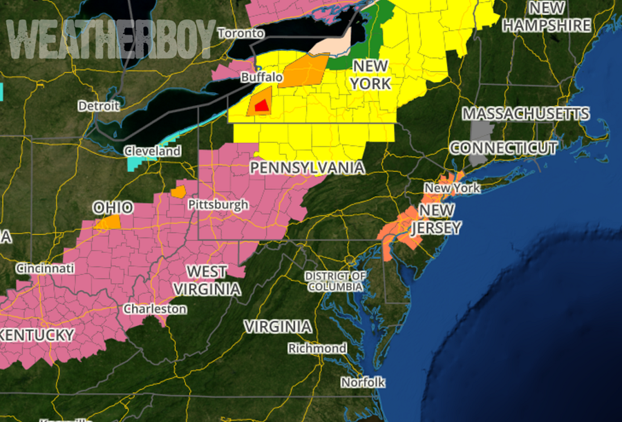
Numerous storm clusters and lines are expected to develop this afternoon and progress east-northeast. Strong gusts producing damaging winds and a couple tornadoes are anticipated, according to the National Weather Service’s Storm Prediction Center. As a result, a tornado watch was issued for portions of New York, Vermont,  and Pennsylvania.

A Tornado Watch means conditions are favorable for tornadoes and severe thunderstorms in and close to the watch
area. Persons in these areas should be on the lookout for threatening weather conditions and listen for later statements and possible warnings. Some warnings have already been issued for possible tornadoes spotted by observers on the ground or by National Weather Service weather RADAR.


South of the Tornado Watch area, the National Weather Service issued a Severe Thunderstorm Watch. Here, scattered damaging winds appear likely as numerous clusters and lines of storms intensify and move east this afternoon.

The severe thunderstorm watch area is approximately along and 105 statute miles east and west of a line from 15 miles northeast of Dubois, PA to 60 miles south southeast of Louisville, KY.

A Severe Thunderstorm Watch means conditions are favorable for severe thunderstorms in and close to the watch area. Persons in these areas should be on the lookout for threatening weather conditions and listen for later statements and possible warnings. Severe thunderstorms can and occasionally do produce tornadoes.

Primary Sidebar

Sponsored Ad

Search

Latest News

  • New York City Rattled by Earthquake
  • Very Heavy Snow, Severe Thunderstorms, and Damaging Winds Head to Hawaii
  • Severe Thunderstorm and Tornado Threat Marches East
  • Strong Earthquake Hits Louisiana; State’s Second Largest Quake Ever
  • Melissa Never to Be Used Again for Hurricanes; Molly Added to List
  • Person Dies at Kilauea Volcano in Hawaii
  • Another Day, Another Stronger Earthquake Inside the New Madrid Seismic Zone in Missouri
  • Morning Earthquake Rattles Heart of New Madrid Seismic Zone
About | Careers | Contact | Contests
Terms | Privacy | Ad Choices
Weatherboy is a (R) Registered Trademark of isarithm LLC, All Rights Reserved.
All content herein is Copyright by Isarithm LLC 1997-2022

Insert/edit link

Enter the destination URL

Or link to existing content

    No search term specified. Showing recent items. Search or use up and down arrow keys to select an item.