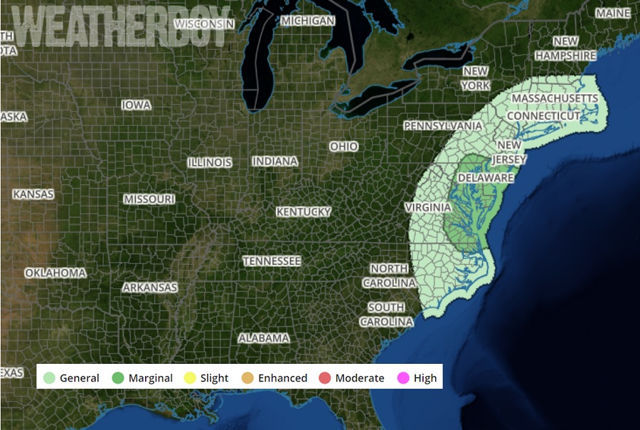
The same system responsible for today’s blizzard conditions in Nebraska may trigger severe thunderstorms in portions of the eastern United States tomorrow. Thunderstorms are possible from portions of the Mid-Atlantic into southern New England Tuesday morning through Tuesday afternoon and across the southern Florida Peninsula Tuesday afternoon. According to the National Weather Service’s Storm Prediction Center, a couple storms across the Mid-Atlantic may produce gusty winds and perhaps a brief tornado Tuesday morning. While the chance of a tornado forming is low, the best chance for one to form is over southern New Jersey, Delaware, southeastern Pennsylvania, eastern Maryland and Virginia, and northeastern North Carolina. Because of this threat, the Storm Prediction Area has identified this area as having a “marginal” threat in their latest Convective Outlook for Tuesday.
A large closed, mid-level low is responsible for this severe weather risk. The low will continue its east and northeastward progression early Tuesday, gradually opening as it lifts into the St. Lawrence Valley in Canada. Concurrently, an occluded surface low will advance across southern Ontario and Quebec. To its south and southeast, a front will sweep eastward across the Mid-Atlantic and Southeast, ushering in a continental air mass through the day. Ahead of the front, southerly flow will transport surface dew points in the upper 50s to lower 60s northward across the Mid-Atlantic late tonight. Forcing for ascent associated with the larger-scale trough, in addition to a nose of strengthening warm-air advection lifting north over the Mid-Atlantic, should foster small convective bands accelerating east towards the coast through the morning hours. In non-meteorological terms, conditions will be ripe to form a broken line of showers and storms in the Mid Atlantic during the morning hours, and some of those cells could be severe. While most updrafts will likely be too weak and disorganized to yield a severe threat, forecast soundings indicate enough potential for a few stronger surface-based updrafts. Considering the strength of low-level shear and overall flow, such convective elements may yield localized instances of gusty, damaging winds and perhaps a brief tornado Tuesday morning.
Once the system clears the coast, the atmosphere will stabilize, bringing back calm, fair conditions to the region.
