• Skip to primary navigation
  • Skip to main content
  • Skip to primary sidebar

Weatherboy

Weatherboy Weather News, Maps, RADAR, Satellite, and Forecasts.

  • Local
  • Earth Science News
  • RADAR
  • Current Warnings
  • Satellite
  • Current Maps
  • Forecast Maps
  • Video

Shocking 3 Day Forecast: 100°, Fire Weather, Heavy Snow

by Weatherboy Team Meteorologist - September 6, 2020

Despite temperatures flirting with 100 today, heavy snow is forecast to impact portions of the Rockies, prompting the National Weather Service to issue Winter Storm Watches for the region. Image: NWS


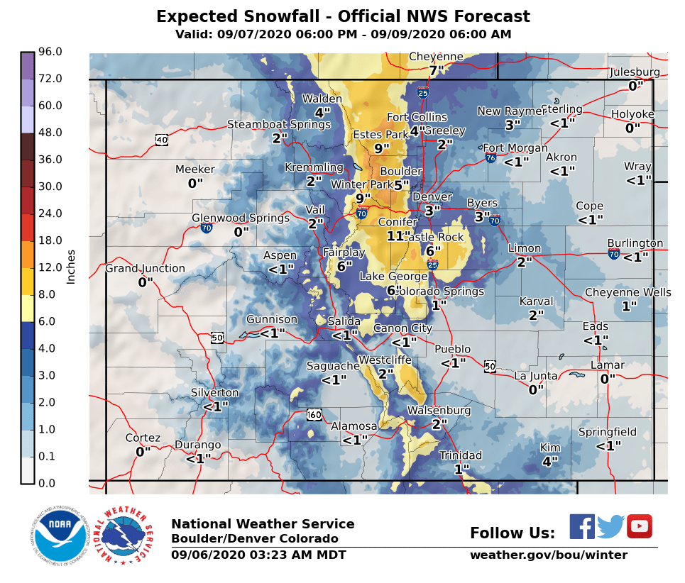
While portions of Colorado do experience drastic changes with weather conditions during the spring and fall, conditions will be remarkably extreme over the next three days. Within a 72 hour period, places that include the Denver metro area, could see record heat, dangerous fire weather conditions, and heavy record-setting snow.

Winter will make an early arrival as a strong system from the north will bring much colder temperatures as well as accumulating snow to the region. Temperatures will drop quickly behind a cold front Monday night with snow starting shortly after midnight over the higher terrain and foothills. Snow levels are expected to drop Tuesday morning, with accumulating snow possible for the Front Range, I-25 corridor and Denver Metro areas. Snow falling on trees in full leaf may cause branches to break or other tree damage. Scattered power outages will also be possible. Roadways could become slippery and slushy across the higher terrain. The system will move out by Wednesday with snowfall coming to an end and
conditions improving.


While Winter Storm Watches are up, temperatures will flirt with 100 in many areas today.  Image: NWS
While Winter Storm Watches are up, temperatures will flirt with 100 in many areas today. Image: NWS

But before the cold and snow arrive, record heat will persist along with fire weather conditions.  The National Weather Service is calling for very hot weather today, with 102 expected in Fort Morgan, 101 in Pueblo, 97 in Denver, 96 in Boulder, and 95 in Colorado Springs.

When the temperature at Denver International Airport reached 91 at 10am this morning, it became the  72nd “90” for the year. The all time record is 73 which occurred in 2012.


Fire Weather conditions will persist before the cold and snow arrives.  Image: NWS
Fire Weather conditions will persist before the cold and snow arrives. Image: NWS

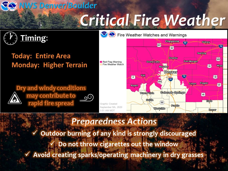
Very hot and dry conditions combined with windy conditions are also making for prime wildfire conditions. The National Weather Service says the fire danger is very high to extreme today and Monday, prompting them to issue Red Flag Warnings. The National Weather Service is urging people to avoid any outdoor activity that may produce a spark and start a new wildfire.


Primary Sidebar

Sponsored Ad

Search

Latest News

  • Solar Flare Triggers New Geomagnetic Storm Watch for Tuesday
  • Geomagnetic Storm WARNING In Effect; Strong Storm Expected
  • Tropical Depression Forecast to Fizzle East of Hawaii
  • Another Stronger Quake Rattles Ohio, Second in Two Days
  • Tropical Storm Philippe Forms in the Atlantic
  • Flood, Tornado Threats Persist After Landfall of Ophelia
  • Storm Surge Likely from South Carolina to New Jersey as Ophelia Makes Landfall
  • Tropical Storm Ophelia Continues to Gain Strength
About | Careers | Contact | Contests
Terms | Privacy | Ad Choices
Weatherboy is a (R) Registered Trademark of isarithm LLC, All Rights Reserved.
All content herein is Copyright by Isarithm LLC 1997-2022