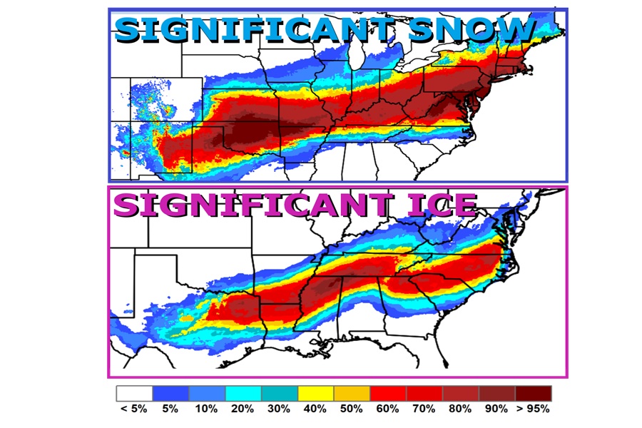
Significant snow and ice is likely to impact a large part of the U.S. in the coming days with the worst of the impacts arriving over the weekend. A crippling ice storm is expected in portions of the south while very heavy snow is likely in portions of the Ohio River Valley into the Mid Atlantic and New England. The duration and size of the storm is significant; this will be a multi-day event over a region stretching from Texas to Massachusetts, bringing significant impacts to major metros like Dallas, Houston, Little Rock, Nashville, Raleigh, Roanoke, Washington DC, Baltimore, Philadelphia, New York, Hartford, and Providence.
Beginning on Thursday, a strong area of high pressure in western Canada will aid in bringing a frigid arctic air mass originating from the northern Plains, after the passage of an arctic cold front. Frigid below-average temperatures will expand from the Northern Plains into Southern Plains and across the majority of Central and Eastern U.S. by the weekend. This will be accompanied by gusty winds, leading to dangerous wind chills. The coldest wind chills may fall below -50F across the Northern Plains, with sub-zero wind chills reaching as far southeast as the Mid-Atlantic states and Southern Plains.
With the gusty winds, cold temperatures, and snowfall, parts of the Upper and Mid Mississippi Valley are under a Blizzard Warning this evening. In addition, several areas have issued Extreme Cold Watches/Warnings through Saturday.
The time is NOW to make proper preparations ahead of the big winter storm that'll impact a very wide area stretching from Texas across the south and into the Northeast! pic.twitter.com/MkOUCddvGS
— the Weatherboy (@theWeatherboy) January 21, 2026
Heading into Friday, a low pressure system will continue to dig into southwestern U.S. and will eject into the Plains, promoting cyclogenesis, frontal development, and southerly return flow. This will bring a significant winter storm that will produce heavy snow, sleet, and freezing rain from the Southern Rockies/Plains and Mid-South into the East Coast.
The National Weather Service is warning that beyond the extreme cold temperatures, people should “expect prolonged snow and ice impacts, which may include hazardous travel conditions, power outages, tree damages, snow-covered roads, and reduced visibility.”
