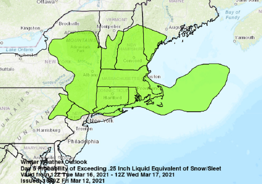
While the astronomical marches towards spring, there could be some wintry weather arriving in portions of the Northeast next week. The National Weather Service’s Weather Prediction Center has issued a new outlook suggesting measurable snow and/or sleet could fall across portions of New Jersey, Pennsylvania, New York, Vermont, New Hampshire, Massachusetts, Rhode Island, and Connecticut next Tuesday and/or Wednesday.
Colder air will arrive to the northeast in advance of this next weather system. A cold high pressure system is forecast to build down from Ontario and into the Mid Atlantic Monday and Monday night. Dry weather is expected along with temperatures about 6 to 8 degrees below normal.
Beyond Monday, conditions will become unsettled in the northeast. A mid level low is forecast to be located over the central Great Plains on Monday morning, with another mid level low near the coast of northern California. The first low is expected to become and open wave on Monday night and Tuesday as it lifts over the Great Lakes. The second low should work its way eastward, reaching the Ohio River Valley on Thursday before becoming and open wave. As Monday`s surface high drifts off the coast, moisture associated with the first mid level low is expected to bring some precipitation to the northeast on Tuesday.
Snow and/or sleet could fall on Tuesday and Wednesday in portions of the northeast and there could be accumulating wintry precipitation. South into southern Pennsylvania and southern New Jersey and points south of there, it appears for now that conditions will be too mild for anything other than plain rain. In between these areas, a wintry mix of snow, sleet, and rain is possible.
A break in the potential for precipitation is expected for Wednesday night. However, moisture ahead of the second mid level low and it surface reflection may begin to arrive in the northeast on Thursday. Temperatures could be too warm to support wintry precipitation then, but it is too soon to say so with a great amount of certainty.
