• Skip to primary navigation
  • Skip to main content
  • Skip to primary sidebar

Weatherboy

Weatherboy Weather News, Maps, RADAR, Satellite, and Forecasts.

  • Local
  • Earth Science News
  • RADAR
  • Current Warnings
  • Satellite
  • Current Maps
  • Forecast Maps
  • Video

Snow Threat This Weekend, Larger Threat Next Weekend

by Weatherboy Team Meteorologist - January 12, 2019

The American GFS computer forecast model is suggesting an even more robust and far-reaching winter storm will develop along the East Coast next weekend, producing heavy precipitation from Maine to Florida. The precipitation could fall as significant snow from Maine to South Carolina. Image: tropicaltidbits.com


An area of low pressure is dropping snow from eastern Nebraska and Kansas into portions of the Ohio Valley, and will eventually bring measurable snow to portions of Virginia, Maryland, and Delaware later tonight into tomorrow. While some snow here could be significant, with the National Weather Service issuing Winter Storm Warnings for areas that could see more than 6″ of snow, it appears an even larger winter storm threat could be looming for next weekend.

A variety of warnings, watches, and advisories are up now as a storm system heads to the East Coast today. Image: weatherboy.com

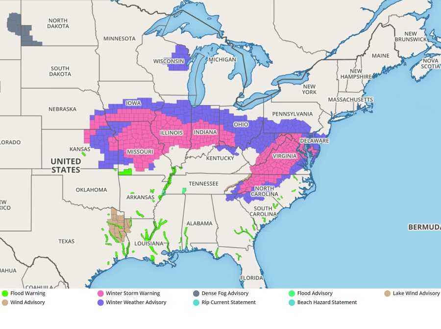
Today’s storm system has triggered a variety of advisories, watches, and warnings. Each of these is issued by the National Weather Service for a county-by-county basis, with each county having advisory criteria that could be different from other county criterias. Regardless of the advisory or warning up, travel could become tricky if not dangerous over a large part of the eastern U.S. this weekend; motorists are urged to travel with caution and care if they need to be out and about.


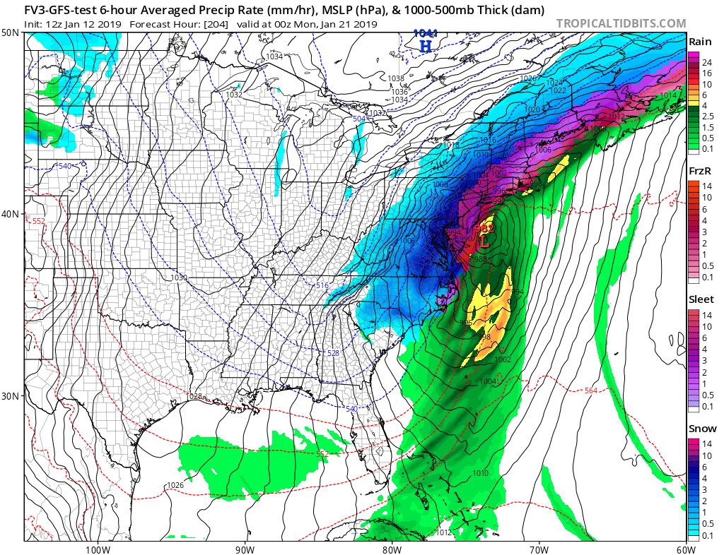
But while many will deal with a winter storm today, an even larger storm is being modeled by some computer-generated forecasts for next weekend. Both the European ECMWF and American GFS are depicting a heavy-snow producer for portions of the Eastern U.S.; in addition to heavy snow, the precipitation shield from this large storm will be quite vast, stretching along the entire U.S. East Coast. With more cold air to work with than today’s system, next weekend’s system may produce a substantially wider snowfall. While it is too soon to lock-in forecast amounts for a system more than a week away, it is possible that more than a foot of snow could fall near or on the heavily populated I-95 corridor by next Sunday.


While the weather pattern hasn’t been favorable for big snow in the northeast over the last month, it appears that could be changing in the coming days as January 2019 closes.


Primary Sidebar

Sponsored Ad

Search

Latest News

  • Greatest Threat for Tornadoes on Saturday in the U.S. will be in New Jersey & Delaware
  • Watches, Warnings for High Winds Issued for Expected Damaging Gusts
  • TV Meteorologist Dr. Frank Field Turns 100
  • Particularly Dangerous Situation Unfolding Over Iowa, Illinois, Missouri with Violent Storms, Tornadoes
  • Fiona and Ian Retired from Storm Name List; Farrah and Idris to be Added
  • Severe Weather Threat Returns to Mississippi Valley on Friday
  • Deadline for SBA Aid for Kauai Drought Coming Soon
  • Another Atmospheric River Event Slams into West Coast; More Epic Rain, Snow Expected
About | Careers | Contact | Contests
Terms | Privacy | Ad Choices
Weatherboy is a (R) Registered Trademark of isarithm LLC, All Rights Reserved.
All content herein is Copyright by Isarithm LLC 1997-2022