• Skip to primary navigation
  • Skip to main content
  • Skip to primary sidebar

Weatherboy

Weatherboy Weather News, Maps, RADAR, Satellite, and Forecasts.

  • Local
  • Earth Science News
  • RADAR
  • Current Warnings
  • Satellite
  • Current Maps
  • Forecast Maps
  • Video

Stormy Double Trouble

by Weatherboy Team Meteorologist - July 22, 2017

The National Weather Service Storm Prediction Center's Convective Outlook shows severe weather threats. The yellow area on the map shows the best chances for severe weather today (top) and tomorrow (bottom.) Map: weatherboy.com
The National Weather Service Storm Prediction Center’s Convective Outlook shows severe weather threats. The yellow area on the map shows the best chances for severe weather today (top) and tomorrow (bottom.) Map: weatherboy.com


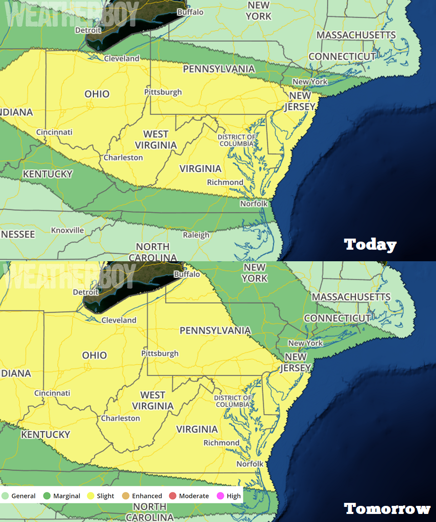
With an impressive amount of heat and humidity available to work with, there will be several chances of severe weather in portions of the Mid Atlantic over the next 48 hours; so much so, the National Weather Service’s Storm Prediction Center’s Convective Outlook can be described as a “stormy double trouble” with two days of severe weather expected.

While there’s low-confidence in forecast minutia with where the storms will fire-up, there is high confidence they’ll fire up in the areas shaded in yellow on the Convective Outlook maps provided by the Storm Prediction Center. An area stretching from central Indiana to southern New Jersey is most likely to see the thunderstorm action, with Philadelphia, Baltimore, Wilmington, Norfolk, Richmond, and Washington, DC also in an area favorable for severe storms.


With a slow-moving boundary, midlevel flow oriented parallel to it, very high precipitable water values of 2″+,  and potential for training/upwind propagation effects, locally excessive rainfall is possible. The National Weather Service says too much uncertainty exists for a flood watch at this time, especially given the relatively dry antecedent
conditions, but  some local instances of poor-drainage/urban flooding are probable and isolated flash flooding
is possible.

Remember: turn around, don’t drown! Never drive through flooded roadways.

The hot, humid, stormy conditions will persist for the next 48 hours, with no significant relief expected for a few more days.

Primary Sidebar

Sponsored Ad

Search

Latest News

  • Southeast Soaker Likely Next 72 Hours
  • Igloo Cooler Recalled Due to Amputation / Crushing Threat
  • Longtime TV Meteorologist Fired
  • Spacecraft Launched by Soviet Union in 1972 Crashed Back on Earth Today
  • Strong Tennessee Earthquake Reported by 35,000+ People
  • Updated Crash Forecast Puts Eastern U.S. on Alert from Soviet Union Spacecraft
  • Soviet Union Spacecraft Crash Zones Updated; NJ/NY/PA/MI at Increased Risk
  • Over 2,000 People Report Shaking from Virginia Earthquake
About | Careers | Contact | Contests
Terms | Privacy | Ad Choices
Weatherboy is a (R) Registered Trademark of isarithm LLC, All Rights Reserved.
All content herein is Copyright by Isarithm LLC 1997-2022