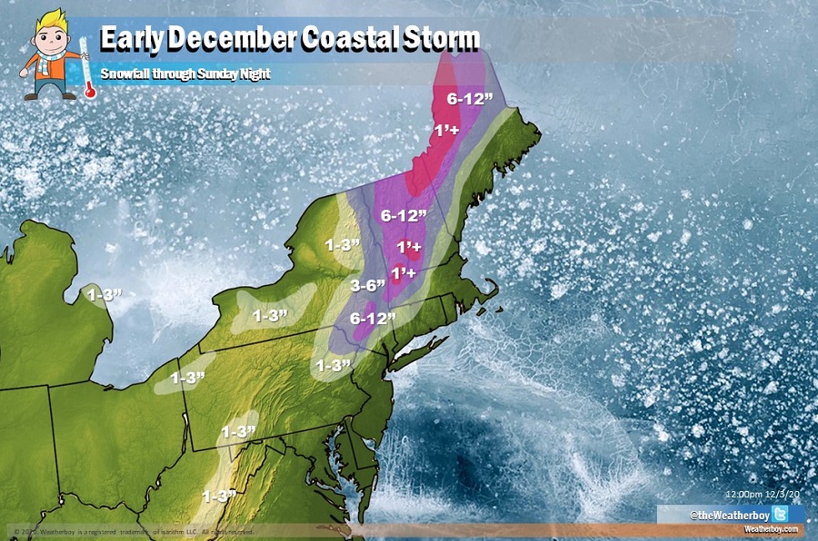
A strong coastal storm is forecast to bring substantial snow and heavy rain to portions of the northeast this weekend as gusty winds and rough surf lash the coast. Because this is an early December coastal storm with limited cold air to work with, much of the coastal plain, especially from New York City south, will see plain rain. While the I-95 corridor from New York south will be quite wet and windy, areas north and west of there could see significant snow, with some ski resorts of interior New England forecast to receive more than a foot of snow by Sunday night.
A southern stream shortwave and associated low pressure system will advance north and east tomorrow, attempting to phase energy moving south from the northern jet stream. Ahead of this system’s arrival, moisture will be streaming in up the east coast, producing rain showers over the Mid Atlantic by midday tomorrow. However, as the storm arrives and the energy comes together, a more robust storm will unfold tomorrow night into Saturday. Wind-whipped rains will lash the coast as this system develops while enough cold air available over inland locations will help produce snow, heavy at times, especially over higher terrain. Most of the precipitation should fall during the first half of Saturday; however, some precipitation will linger over interior portions of northern New England into Sunday.
The exact track, depth, and evolution of the storm will also determine how much cold air gets drawn into the system which could result in a little snow along the system’s southern fringes over the southern Poconos and northwestern New Jersey. For now, it appears some light snow on the order of 1-3″ will be possible. No accumulating snow is expected at this time in New York and Philadelphia and places south and east. But for locations north of there, snow could be quite significant with 6-12″ possible over the highest terrain of southern Upstate New York, much of Vermont and New Hampshire, and northern Maine. In northwestern Maine and in the highest elevations of Vermont and New Hampshire, more than a foot of snow could fall.
Heavy snow could make for difficult travel in these areas Saturday and Sunday. Travelers, especially those planning to traverse through higher terrain, are encouraged to start travel early or postpone it until the storm exits.
Heavy rain could also create flooding problems on the warm side of the storm, with 1-2″ possible over New York City, Long Island, much of New Jersey, Delaware, and eastern Maryland. Due to recent rains here, flooding could be a concern along the tributaries of the lower Delaware River Basin; some flooding is also possible around the Passaic and Raritan rivers.
In addition to substantial precipitation, winds will become strong and gusty, especially Saturday and Saturday night. In this area, winds, initially out of the north and north east, will blow at 20-30 mph with gusts of 35-45 mph possible. Winds will rotate to the northwest as the storm slides into Canada later Saturday night into Sunday. Cold air coming in from the northwest could turn lingering light rain showers over to snow showers and flurries over eastern Pennsylvania and northern New Jersey. At night, this reinforcing shot of colder air moving south and east could also freeze any wet, untreated surfaces that don’t dry from the earlier winds. As such, people should exercise caution on any untreated surfaces Saturday night, even in areas that only saw rain.
Once the storm exits into Canada on Sunday, precipitation will gradually exit the U.S. while winds will relax. Fair high pressure will return, keeping the region dry through most of the upcoming week.