
According to USGS and the University of West Indies Seismic Research Centre Seismic Research Centre (UWI-SRC) , a strong earthquake struck the Venezuela Coast a short time ago. There is no threat of tsunami at this time in the area of the epicenter, the Caribbean and Bahamas, and the U.S. East Coast; the National Weather Service’s Pacific Tsunami Warning Center, which tracks and warns about activity in the Caribbean too, has not issued any bulletins about any possible threat from this earthquake at this time.
According to USGS, at 8:38 pm ET, outside of Yaguaraparo, Venezuela, a magnitude 5.0 earthquake struck from a depth of 123 km. While USGS hasn’t logged any other earthquake activity in the region, the UWI-SRC reports there were two “events” northwest of Trinidad earlier tonight and they are manually reviewing that earthquake data to see if it’s related. A depth of 123 km is a deep earthquake but others that have struck in this area over the last 6 months have struck between 100 and 151 km.
People on social media report shaking around Grenada, Trinidad and Tobago, and around northern Venezuela.
Northern Venezuela is located on a complex fault zone where the Caribbean and South American tectonic plates interact, making the region prone to earthquakes. This complex boundary zone has deformed the crust over millions of years, creating an intricate network of active faults, including major ones like the Boconó and El Pilar faults. Consequently, a significant portion of the population on Venezuela lives in areas with active seismic zones. A major earthquake in 1812 on the Boconó fault devastated cities like Merida and Caracas, and a 1967 earthquake caused widespread damage along the northern coast, not far from this evening’s earthquake.
Three weeks ago a magnitude 4.8 earthquake struck just east of tonight’s earthquake near Mucurapo, Port of Spain. Four weeks ago, a magnitude 6.3 earthquake struck well west of these earthquakes closer to the coastal border with Columbia near Lagunillas in Zulia.
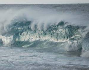
Tsunamis are giant waves caused by earthquakes or volcanic eruptions under the sea. Out in the depths of the ocean, tsunami waves do not dramatically increase in height. But as the waves travel towards land, they build up to higher and higher heights as the depth of the ocean decreases. The speed of tsunami waves depends on ocean depth rather than the distance from the source of the wave. Tsunami waves may travel as fast as jet planes over deep waters, only slowing down when reaching shallow waters. While tsunamis are often referred to as tidal waves, this name is discouraged by oceanographers because tides have little to do with these giant waves.
The National Oceanic and Atmospheric Administration (NOAA) is the agency that monitors tsunamis around the U.S. through its Tsunami Program, which includes the National Weather Service (NWS) and its National Tsunami Warning Center in Palmer, Alaska and the Pacific Tsunami Warning Center in Honolulu, Hawaii. While the Pacific has more seismic activity than the Atlantic and therefore a greater chance at tsunami, they do occur in the Atlantic and Caribbean and the NWS centers are designed to cover those threat zones too. The National Tsunami Warning Center monitors the continental U.S., Alaska, and Canada. The Pacific Tsunami Warning Center monitors the Hawaiian Islands and U.S. Pacific and Caribbean territories
NOAA utilizes advanced observation systems, including its Deep-ocean Assessment and Reporting of Tsunamis (DART) buoys and seismic networks, to detect, warn, and forecast potential threats.
