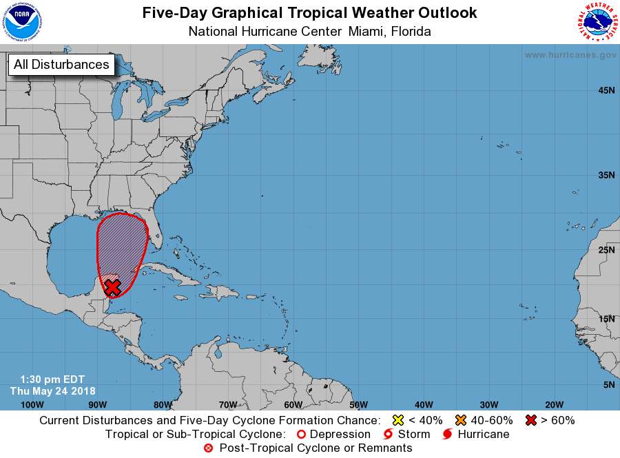
The National Hurricane Center (NHC) now believes there is a high chance -90%- that a subtropical or tropical cyclone will form in the eastern Gulf of Mexico in the coming days. In a special Tropical Weather Outlook issued this afternoon, the NHC pegs the chances of development at 90% over the next 5 days and 70% over the next 48 hours.
The area in concern is still not in the Gulf of Mexico but should be this weekend. A broad surface low drifting slowly northward over the eastern Yucatan Peninsula continues to become better defined. Although showers and thunderstorms, along with strong gusty winds, remain primarily over the adjacent waters of the northwestern Caribbean Sea, environmental conditions are forecast by the NHC to become more conducive for development through early next week, and a subtropical or tropical depression is likely to form by late Saturday over the
southeastern Gulf of Mexico.
An Air Force Reserve reconnaissance aircraft is scheduled to investigate the disturbance tomorrow afternoon, if necessary.
Even if the system doesn’t organize into a subtropical or tropical system, locally heavy rainfall is expected across western Cuba and over much of Florida and the northern Gulf Coast into early next week. In addition, the threat of rip currents will steadily increase along the Gulf coast from Florida westward to Louisiana over the Memorial Day weekend.
While the 2018 Atlantic Hurricane Season officially starts on June 1, having a system form in the days before the season isn’t completely unheard of. The first system to be named of the 2018 season will be called Alberto. While the 2018 Atlantic Hurricane season doesn’t begin until June 1, storms will sometimes form before the season. If this storm