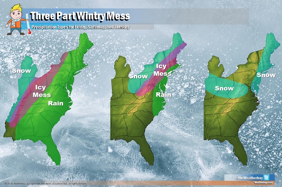
A three part wintry mess will unfold over the Eastern United States in the coming days, eventually bringing snow to a large part of the region. The complex weather pattern will help transition cold air to milder air and then quickly transition that mild air back to very cold air for many locations.
The activity picks up in earnest late Thursday. A trough will slide eastward from the Midwest and Gulf Coast states Thursday into Friday. While the rough slides east, an upper-level ridge will shift more off-shore off the East Coast. A strong shortwave within that trough will swing northeast into the Great Lakes region on Saturday. As that system moves into the Great lakes, an upper-level trough amplifies in the East throughout the weekend, setting the stage for a significant cool-down. While the trough will relax a bit early next week, the stage should be set for another round of snow in the Ohio River Valley and portions of the Mid Atlantic and New England. The evolution and movement of these weather systems will create precipitation across a wide area, in many different forms.
On Thursday, the upper-level trough from the Midwest to the southern Plains will move east, with the southern energy becoming dominant. It is this energy that will develop surface low pressure
along a strengthening baroclinic zone. Down stream of this baroclinic zone, warm air advection will continue across the East as a deep southwesterly flow transports warmer and more moist are from the Gulf of Mexico area to New England. On Thursday night, atmospheric ingredients will come together to create more precipitation in the East. For places like Philadelphia, New York City, and Boston, the strong southwesterly flow should bring milder air and liquid precipitation and some of that liquid precipitation could be heavy at times. With strong warm air advection, overnight temperatures Thursday into Friday may even rise a bit for the I-95 corridor. There’s also a risk of thunderstorms, especially along and south of the heavily populated I-95 corridor. And in gaps of rain, fog is likely to develop as dew points rise at night.
On Friday, the main event becomes to unfold, with the first of three parts precipitating across the eastern United States. Southern stream energy will push northeastward, supporting a surface low along the strengthening baroclinic zone. In this scenario, rain and milder air will surge north to the US/Canada border in New England while cold air wraps behind. While rain is likely even in northern New England on Friday, heavy snow will break out on the back side of the system where cold air is wrapping behind. In between, an icy mess will unfold with plain rain changing to freezing rain and sleet, and areas further west experiencing sleet and freezing rain will change over to plain snow.
On Saturday, the second event unfolds. On Saturday morning, a surface low pressure system should track along the Appalachian Mountains, with some coastal redevelopment possible. If significant coastal redevelopment were to occur, cold air will rush to the Mid Atlantic coast while precipitation moves inland; the result would be accumulating snow to the I-95 corridor. However, at this time, it is more likely that coastal redevelopment will be weak and the low pressure moving into central New England will remain the dominant player. In this more likely scenario, while cold air will race towards the coast, moisture associated with the system should rotate up into New England. This means while rain should linger in places like Philadelphia and New York City in the morning, suburbs just north and west of those areas will see rain change to freezing rain. Further north, freezing rain will change to sleet, and then north of there, sleet will change to plain snow.
Significant snow from the Friday and Saturday event is possible in the northeast, especially across the northern Ohio River Valley moving north and east into western Pennsylvania and western New England. Eventually, heavy snow will also come to northern New England before this second system departs.
On Sunday, a fresh Arctic blast will enter the eastern United States, plunging temperatures back down again. Wet untreated surfaces, especially in the northern Mid Atlantic and southeastern New England, could quickly freeze.
The third event of this 3-part series arrives later Monday into Tuesday. A Clipper-style system will move down from the Great Lakes region while a coastal system may form. Together, snow will break out again, with snow falling well south of where it’ll fall on Friday and Saturday. As a result, places like Philadelphia, Dover, Annapolis, and Ocean City could see another round of plowable snow.
Because of the complexity of these systems and how they are expected to unfold, the forecast for the weekend to the early part of next week remains somewhat questionable. However, as each of the three events approach and confidence increases in the forecast, the National Weather Service will likely issue winter-related advisories, watches, or warnings so that the public is prepared for the wintry weather.