
A multi-day tornado outbreak that brought death and destruction to portions of Oklahoma last night and to portions of Ohio, Kentucky, and Indiana today is likely to extend into tomorrow across parts of the southern Plains into the mid Mississippi, Ohio, and Tennessee Valleys. According to the National Weather Service’s Storm Prediction Center (SPC), all severe hazards, including tornadoes, very large hail, and severe/damaging winds should occur. They also warn that some of the tornadoes may be very strong.
The SPC says a variety of factors will lead to the extended severe weather outbreak. An upper low/trough, initially over the northern Plains Wednesday morning, will develop east to the Upper Midwest/Great Lakes vicinity by Thursday morning. Meanwhile, a more compact upper shortwave
trough over the Lower Great Lakes will shift east/northeast over the Northeastern U.S. This regime will maintain a broad swath of strong upper-level winds; this broad area of enhanced flow aloft will contribute to a strongly sheared environment atop a very moist boundary-layer. While the upper low/trough will progress east through the period, overall height falls across the Midwest and Ohio and Tennessee Valleys are expected to remain modest until overnight. According to the SPC, at the surface, the general expectation is that a surface low over Missouri early in the period will develop east across the Ohio Valley vicinity.
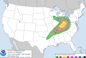
On Wednesday, a very moist and broad warm sector is anticipated around the ArkLaTex into the mid-Mississippi/Ohio/Tennessee Valleys. High dewpoints, ground temperatures, and a plume of steep midlevel lapse rates overspreading the region will aid in strong atmospheric destabilization leading to organized convection. Clusters of severe storms and semi-discrete supercells and bowing line segments possible. Because little atmospheric inhibition is expected across the warm sector, thunderstorm coverage is forecast to be quite widespread.
Initial thunderstorms development is likely during the morning near the triple point in Missouri. Most computer forecast guidance suggests this activity will quickly grow upscale into an eastward advancing line/bow across Missouri. More semi-discrete convection is then anticipated by midday/early
afternoon in the vicinity of the warm front across southern Illinois and western Kentucky spreading east with time across Indiana, Kentucky, and southern Ohio and Tennessee. Additional storms are expected by mid to late afternoon along the cold front across Arkansas, southeast Oklahoma, and northeast Texas. Large to very large hail, up to 2-3″ in diameter, will be possible with more cellular convection given very large instability, steep midlevel lapse rates and favorable vertical shear. The SPC also says that the tornado potential is also apparent, given favorable low-level shear; mesovortex tornado potential also will accompany thunderstorm structures too. Potentially widespread damaging, severe winds appears possible, especially if strong enough cold pools can be generated within linear segments of storms.
Unfortunately for a weather-weary country, it doesn’t appear Wednesday will bring the end to severe weather. More severe storms and threats of tornadic cells will persist into Thursday across portions of the U.S. east coast and southeast.
