• Skip to primary navigation
  • Skip to main content
  • Skip to primary sidebar

Weatherboy

Weatherboy Weather News, Maps, RADAR, Satellite, and Forecasts.

  • Local
  • Earth Science News
  • RADAR
  • Current Warnings
  • Satellite
  • Current Maps
  • Forecast Maps
  • Video

Tornado, Damaging Wind Threats Impact the Mid Atlantic Tomorrow

by Weatherboy Team Meteorologist - June 2, 2021

The area shaded in green on this map reflects where the greatest threat of tornadoes in the U.S. will be on Thursday.  Image: NWS
The area shaded in green on this map reflects where the greatest threat of tornadoes in the U.S. will be on Thursday. Image: NWS


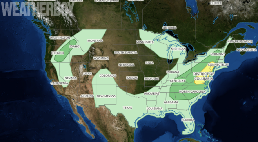
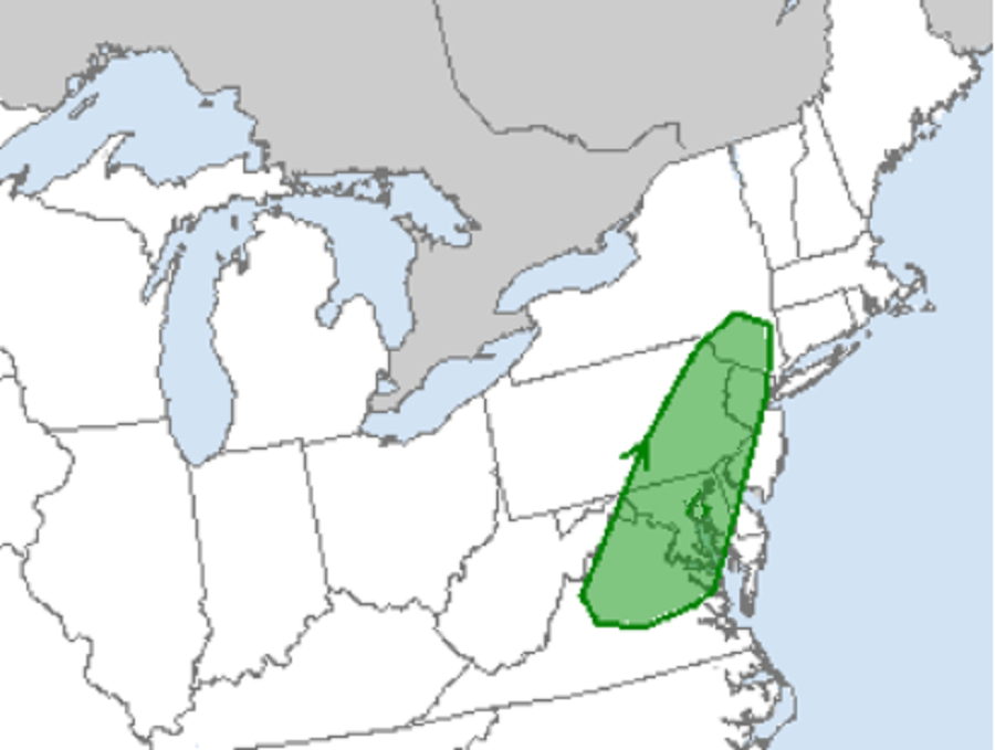
A potent weather system will set the stage for strong to  severe thunderstorms to develop over portions of Virginia, Washington DC, Delaware, Maryland, Pennsylvania, New Jersey, and New York tomorrow. While damaging wind gusts are the primary threat, there is also the possibility of isolated tornadoes in tomorrow’s forecast severe weather.

A shortwave trough will move from portions of the Mid-South into the Mid-Atlantic on Thursday, with w weak frontal boundary  forecast to be pushing through the Ohio Valley into the Appalachians. Ahead of this boundary, moisture return is expected to continue through the day into the Mid-Atlantic and parts of the Northeast. According to the National Weather Service’s Storm Prediction Center, widely-scattered to scattered convection is expected to develop both ahead of the weak boundary and within areas of pre frontal confluence from northern Virginia into southeastern New York. It is this convection that can cause trouble in the form of severe thunderstorms with damaging wind gusts and isolated tornadoes.

A thunderstorm is classified as “severe” when it contains one or more of the following: hail 1″ or greater in diameter, winds gusting in excess of 57 mph, and/or a tornado. The National Weather Service could issue Severe Thunderstorm or Tornado Watches ahead of tomorrow’s expected severe weather impacts.  The National Weather Service could also issue warnings on a county-by-county basis for tornadoes or severe thunderstorms once they’re confirmed and impacted communities on the ground.


The Convective Outlook issued by the National Weather Service's Storm Prediction Center illustrates where thunderstorms could threaten tomorrow. While thunderstorms are possible in the light green area, there's a threat of severe ones in the dark green area. The yellow area reflects the highest risk for severe storms tomorrow.  Image: weatherboy.com
The Convective Outlook issued by the National Weather Service’s Storm Prediction Center illustrates where thunderstorms could threaten tomorrow. While thunderstorms are possible in the light green area, there’s a threat of severe ones in the dark green area. The yellow area reflects the highest risk for severe storms tomorrow. Image: weatherboy.com

Primary Sidebar

Sponsored Ad

Search

Latest News

  • Red Alert: National Weather Service Paints Large Part of Country in Red for Winter Storm Impacts
  • Weak Earthquake Strikes North Carolina Before Winter Storm
  • Weak Earthquake Strikes Heart of New Madrid Seismic Zone Today
  • Weak Earthquake Rattles Connecticut
  • Significant Winter Storm to Bring Over Foot of Snow to I-95 Corridor; Philadelphia & New York to Be Hit Hard
  • Weather Emergency Unfolds in Texas; Winter Storm Watches Up For Dallas, Houston, Austin
  • Significant Snow & Ice Likely to Impact Large Part of U.S. This Weekend
  • Significant, Multi-Day, Large-Scale Winter Storm Developing
About | Careers | Contact | Contests
Terms | Privacy | Ad Choices
Weatherboy is a (R) Registered Trademark of isarithm LLC, All Rights Reserved.
All content herein is Copyright by Isarithm LLC 1997-2022

Insert/edit link

Enter the destination URL

Or link to existing content

    No search term specified. Showing recent items. Search or use up and down arrow keys to select an item.