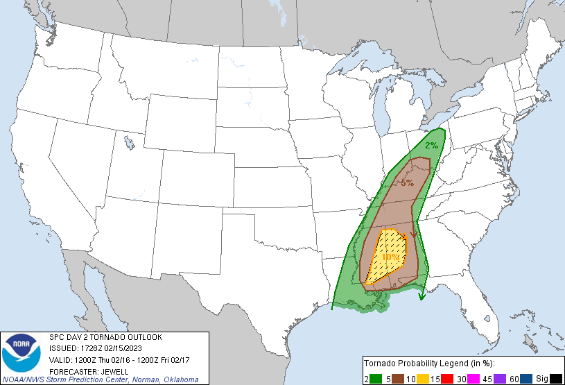
The threat of tornadoes and potentially tornadic cells is growing for Thursday in portions of the Eastern United States. The severe weather happening in the lower Mississippi Valley today will broaden north and south just east of the Mississippi Valley and into the Ohio Valley tomorrow. According to the National Weather Service’s Storm Prediction Center (SPC), there is an enhanced risk of severe thunderstorms from parts of Mississippi and Alabama north into southwest Ohio on Thursday.
Widely scattered severe thunderstorms are likely from the central Gulf Coast states northward into the Ohio Valley on Thursday. Several tornadoes are possible over Mississippi and Alabama, including the risk for isolated strong tornadoes. According to the SPC, an elongated positive-tilt upper trough that is extending from the upper Great Lakes into the southern Plains, with a dry slot developing from St. Louis to Lake Erie, is to blame.
At the surface, low pressure will move from southern Illinois into Ohio by Thursday morning, reaching New England by Friday morning. A cold front will extend south from the low, crossing the Mississippi River by late morning and slicing into the mid Ohio and Tennessee Valleys by late afternoon. This frontal movement, combined with strong upper level winds and a surge of low-level moisture will help foster corridors of severe storms, including a few tornadoes.
According to the SPC, hodographs will be quite favorable for tornadic supercells, with the primary mitigating factor being cool/marginal boundary-layer temperatures. While there is a risk of tornadoes from Louisiana to Ohio, the greatest threat will be over central and western Mississippi and western and central Alabama.
Outside of this elevated tornado threat zone, severe thunderstorms with damaging wind gusts and large, damaging hail are also possible. Frequent lightning and flash flooding from heavy downpours is also an isolated threat throughout this region.
This severe weather will dissipate tomorrow evening, with the risk of severe weather on Friday only returning to portions of the southeast coast. No severe weather is expected in the northeast from this system moving through.
