A winter storm is producing an epic winter mess across a large part of the country, bringing the threat of tornadoes, accumulating ice and snow, and even flooding to portions of the eastern United States after blasting the central U.S. with frozen precipitation and bitter cold. Areas hit hard by hurricanes last season are now dealing with thundersnow and sleet while places in the northeast prepare for yet another round of wintery weather in what seems like an endless parade of snowstorm after snowstorm.
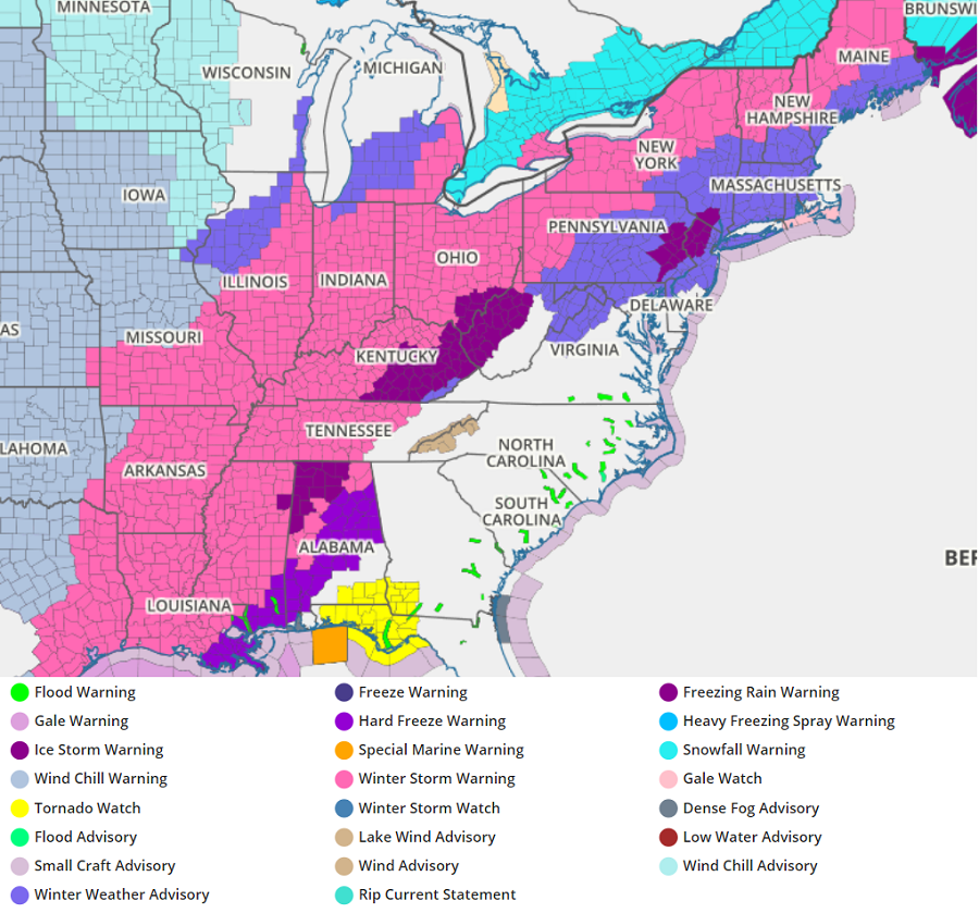
Right now, more than 150 million Americans are currently under Winter Storm Warnings, Ice Storm Warnings, Winter Storm Watches, or Winter Weather Advisories. A major winter storm will continue to spread heavy snow and significant ice accumulations from the southern Plains and Ohio Valley to the northeast.
Over the central states, frigid Arctic air and dangerously cold wind chills will continue to pour in, plunging even portions of the Gulf Coast into a deep freeze.

As this cold air mixes with relatively warmer air that remains over Florida, the clash is creating an area robust for severe thunderstorm development. Beyond severe thunderstorms with heavy rain, scattered tornadoes are also likely across portions of the Florida panhandle. Because of that, the National Weather Service’s Storm Prediction Center has issued a Tornado Watch there today.
While the current areas of snow and wintry mix over parts of the Southern Plains will wrap up today, bitterly cold temperatures will limit the amount of melting today, with treacherous travel conditions likely to persist.
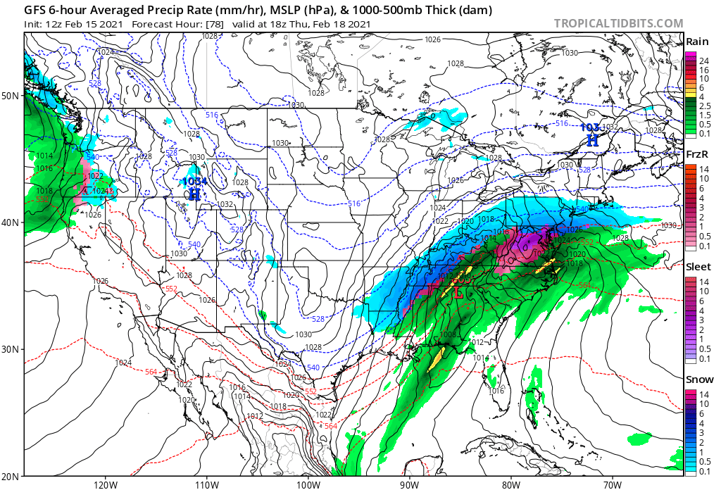
Heavy snow and freezing rain are forecast to advance northeastward today from the Mississippi and Ohio Valleys to the Northeast. A large swath of 6-12″ of snow is forecast from the Ohio Valley and eastern Great Lakes to northern New England. South of the heavy snow axis, freezing rain is expected to cause a numerous problems with over a 1/10″ of ice in the forecast from far east Texas northeastward to southern New England. Significant ice amounts of 1/4″- 1/2″ are expected in portions of the Lower Mississippi Valley and the Mid-South leading to dangerous travel conditions, numerous power outages, and extensive tree damage. Precipitation will likely stay rain for the southern Mid-Atlantic and Southeast where cold air is more limited.
While snow has been the dominant precipitation type in Texas, rain will be the dominant precipitation type in the northeast as the storm moves into the region tomorrow. While a snowy or icy start is possible away from the coast, the rain/snow line should push north throughout Pennsylvania, all but the northernmost parts of New York state, southern Vermont and New Hampshire, and coastal Maine. From here south, plain rain will eventually fall as the storm races north and east to the Canadian Maritimes by early Wednesday.
As the storm exits the United States tomorrow morning, cold air wrapping behind the storm system will help keep any lingering precipitation over Maine and the rest of New England as plain snow on Wednesday. Cold air will also seep into the Mid Atlantic, setting the stage for another round of trouble later in the week.
Later on Wednesday, a new area of low pressure will develop near the Texas/Louisiana border, bringing another round of snow, sleet/freezing rain, and rain to an area dealing with today’s inclement conditions. Unlike today’s storm, it will be milder along the Gulf Coast, bringing more liquid precipitation into areas seeing frozen precipitation today. But the opposite will be the case over portions of the Mid Atlantic, where instead of rain, snow should fall –at least at the start of the system.
By Thursday afternoon, snow will spread into places like Philadelphia and New York City and some of that snow could be heavy at times. At this time, it appears near the I-95 corridor from Philadelphia to Boston, snow will eventually change to sleet/freezing rain and plain rain before the storm exits the coast by Friday night. It is still too soon to say with a high degree of confidence where the rain/snow line for this next system will set-up in the northeast.
While precipitation types and amounts are up in the air for Thursday and Friday in the northeast, one thing meteorologists are confident about is the return of high pressure to the eastern half of the country for Saturday. For a change, precipitation should be absent from Texas to Maine, giving people the chance to recover from a wild week of wintry weather.
