While Hurricane Barry made landfall on the coast of Louisiana yesterday, its impacts will continue for the next several days as its remnants eventually move north and east. Along the way, Barry will be dropping copious amounts of rain, creating widespread flooding threats.
In the latest advisory from the National Hurricane Center (NHC), the center Barry, now a tropical storm, was located by NOAA Doppler radars and surface observations near latitude 32.4 North, longitude 93.6 West. Barry is moving toward the north-northwest near 9 mph. A general northward motion is forecast tonight through Monday morning. A motion toward the north-northeast and northeast is expected Monday afternoon into Tuesday. On the forecast track, the center of Barry will move across the northwestern portions of Louisiana today, and over Arkansas tonight and Monday. Those same NOAA Doppler weather radar data and surface observations indicate that maximum sustained winds remain near 40 mph with higher gusts. These winds are occurring near the coast well to the southeast and south of the center. Weakening is expected as the center moves farther inland, and Barry is forecast to weaken to a tropical depression later today. The estimated minimum central pressure is 1007 mb (29.74 inches).
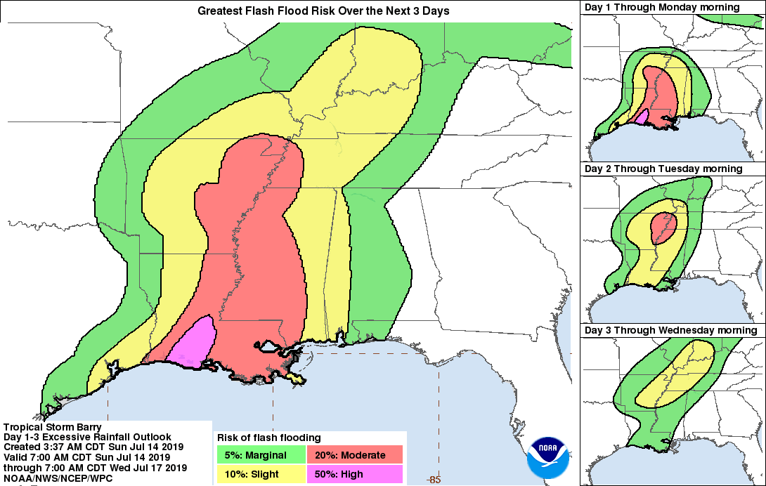
Hazards dealing with storm surge, flooding rains, strong winds, and tornadoes continue. According to the NHC, water levels along the southern coast of Louisiana are gradually receding. However, some minor coastal flooding is still possible through today. Barry is expected to produce additional rain accumulations of 6 to 12 inches over south-central Louisiana, with isolated maximum amounts of 15 inches. Across the remainder of the Lower Mississippi Valley, total rain accumulations of 4 to 8 inches are expected, with isolated maximum amounts of 12 inches. This rainfall is expected to lead to dangerous, life-threatening flooding. Tropical storm conditions are occurring across portions of the Tropical Storm Warning area, and these conditions will persist through early this afternoon. A couple of tornadoes are possible today across portions of southeastern Louisiana, Mississippi, western Alabama, eastern Arkansas, and western Tennessee.
Beyond tomorrow, computer forecast models show Barry’s remnants bringing significant soaking rains to the mid Mississippi Valley, the Ohio Valley, and eventually into the Mid Atlantic by next weekend. Residents along the potential future track of Barry’s remnants should closely monitor evolving forecasts and heed the advice of local officials should flood advisories or evacuation orders be given.
