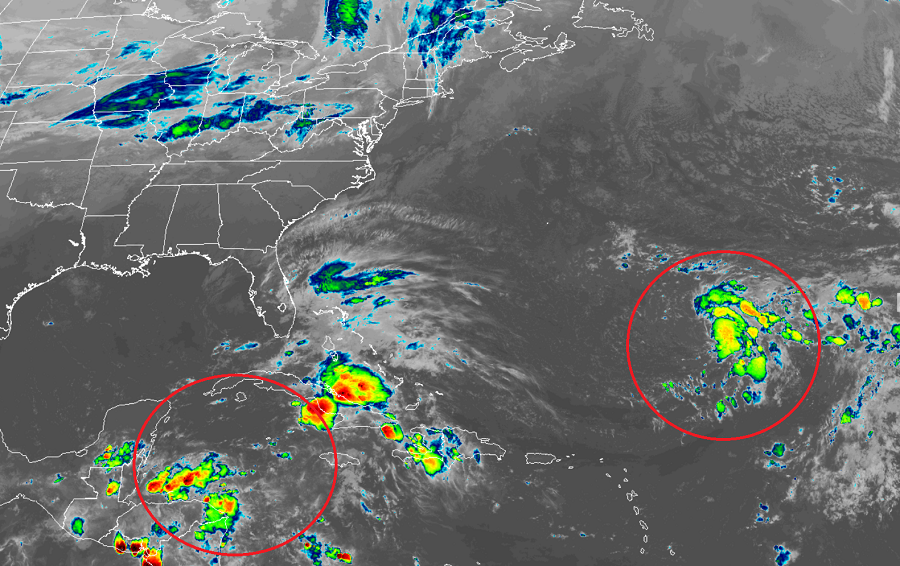
The National Hurricane Center continues to track two areas of concerns within the Atlantic Hurricane Basin; one is likely to form into a tropical or subtropical cyclone within the next day or two. The second system may also become a tropical cyclone or could help set the stage for a significant U.S. east coast storm over time.
The first area of concern is located in the Atlantic about 700 miles southeast of Bermuda. Showers and thunderstorms associated with a large non-tropical low pressure system here remain poorly organized and displaced mainly to the east of the low-level center. According to the National Hurricane Center, environmental conditions are forecast to be only marginally conducive for development during the next day or two. Although a subtropical or tropical depression could still develop during that time, upper-level winds are expected to become more favorable for tropical cyclone formation to occur by late Tuesday and Wednesday while the low meanders well to the southeast of Bermuda. Should the system become a named tropical storm, it would be called Epsilon. The National Hurricane Center says there’s a 90% chance that this will develop into a tropical cyclone over the next 5 days.
The second area of concern is located in the Caribbean. According to the National Hurricane Center, a broad area of low pressure could form in a couple of days over the southwestern Caribbean Sea. Some gradual development of this system is possible late this week while it moves slowly northwestward or north-northwestward over the western Caribbean Sea. The National Hurricane Center believes there’s a 20% chance of tropical cyclone formation here in the next 5 days.
While computer forecast guidance is in fairly good agreement that the system near Bermuda will develop into a tropical cyclone, forecast guidance isn’t as clear with the Caribbean disturbance. Some forecast model runs suggest this too will become a tropical cyclone over time, while other models suggest instead of developing into a tropical cyclone, it’ll help set the stage for a non-tropical coastal storm near the U.S. East Coast. And while models suggest those active scenarios, some guidance also suggests the system could fade away with the larger system near Bermuda being the dominant area of low pressure in the basin. With conflicted computer guidance, meteorologists have low confidence in any scenario with this storm for now. More will be known and confidence will grow in the upcoming days as each of these systems evolve, offering clues to meteorologists how the systems could grow.
Beyond Epsilon, should another tropical or subtropical storm be named this season, it will be called Zeta. Only once in history was there a Zeta: it happened in December 2005. It is still too soon to know whether or not the 2020 Atlantic Hurricane Season will use that name and names beyond it in what’s already been a year with many broken records.