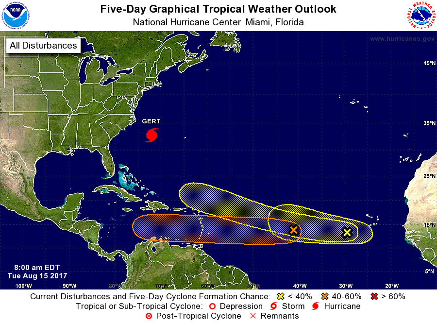
While Hurricane Gert spins about in the Atlantic between the US East Coast and Bermuda, things are becoming very active in the Atlantic as we approach the peak weeks of the Atlantic Hurricane season with a train of threats building. The National Hurricane Center (NHC) is tracking three disturbances which could become tropical cyclones in the coming days. Some long range computer forecast guidance is also suggesting that at least one of these systems could become a landfalling hurricane threat on the US coastline in just over a week from now.
An elongated area of low pressure located more than a thousand miles east of the Lesser Antilles is producing disorganized showers and thunderstorms. This system is expected to move westward at 15 to 20 mph across the tropical Atlantic Ocean, crossing into the Caribbean Sea on Friday. Environmental conditions appear somewhat supportive of tropical cyclone formation over the next few days but should become less favorable once the system moves into the Caribbean Sea. The chance of formation is low over the next 48 hours, with the NHC forecasting only a 20% chance of tropical cyclone formation here. Those odds increase to 40% over the next 5 days.
A second area of low pressure, associated with a tropical wave, is also producing disorganized shower and thunderstorm activity a few hundred miles west-southwest of the Cabo Verde Islands. Environmental conditions could be conducive for some slow development of this system over the next few days while it moves westward to west northwestward at 15 to 20 mph. According to the NHC, chance of tropical cyclone formation here is 10% over the next 48 hours and 20% for the next five days.
A tropical wave over western Africa is forecast to emerge over the far eastern Atlantic Ocean on Wednesday. Conditions appear conducive for some development after that time while the wave moves westward to west northwestward at about 15 mph. The NHC says development is unlikely over the next 48 hours and only 20% through the next five days.
The next tropical cyclone to be named in the Atlantic will be called Harvey.
Before any threat arrives on US shores, residents should make sure their Hurricane Action Plan is in order.
Experts believe this Atlantic Hurricane Season, which runs through to the end of November, will be a busy one. Dr. Phil Klotzbach and the experts at Colorado State University updated their seasonal outlook again on July 5, showing a much more active than normal season expected. The National Oceanic and Atmospheric Administration (NOAA) also released their own forecast which shows this hurricane season to be likely more active than others.
