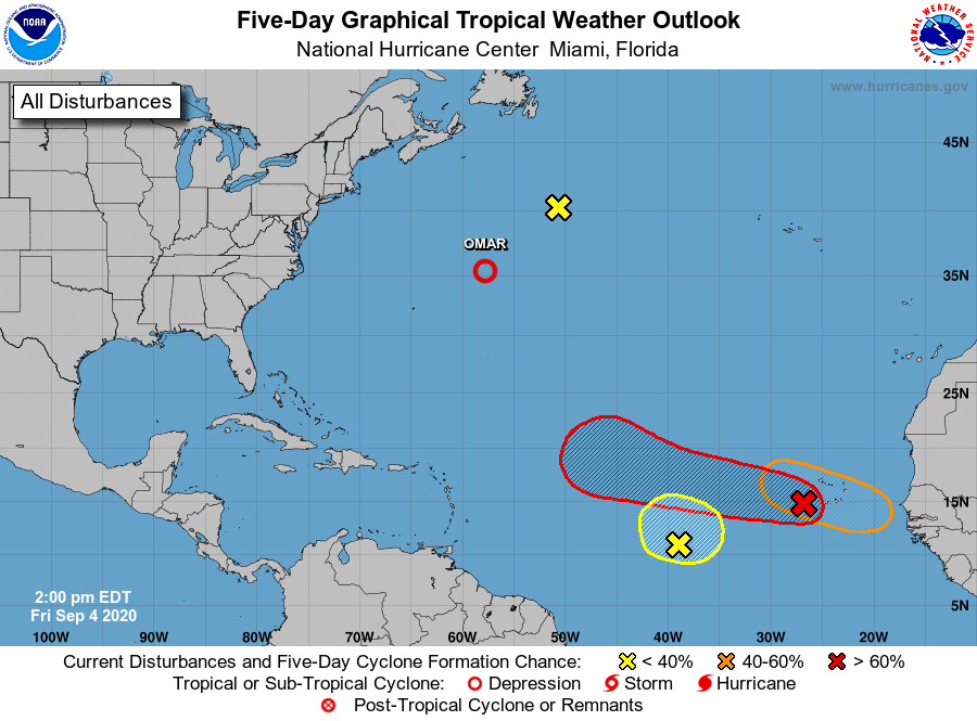
With Hurricane Nana completely dissipated over Central America and what’s left of Omar fading away over the central Atlantic, eyes are returning to a birth hotspot this time of year in the Atlantic: the eastern Atlantic off the coast of Africa. With the traditional peak of hurricane season just a week away, this part of the Atlantic is showing at least three possible areas of tropical cyclone development in the coming days. It’s possible Paulette, the next available name to be used for tropical storms and hurricanes in the Atlantic, will come to life in the coming days, breaking more records for an extremely busy hurricane season.
The most impressive tropical wave of the bunch is an area of low pressure located just west of the Cabo Verde Islands is producing a large area of disorganized showers and thunderstorms. According to the National Hurricane Center, gradual development of this system is expected as it moves westward to west-northwestward, and a tropical depression is likely to form late this weekend or early next week when the system reaches the central tropical Atlantic. The National Hurricane Center believes there is a high 80% chance that a tropical cyclone will form here over the next 5 days.
The second most impressive system is just off the African coast. According to the National Hurricane Center, gradual development of this system is expected with time, with a tropical depression forming by the middle of next week while it moves generally westward over the far eastern tropical Atlantic. For this system, the National Hurricane Center believes there’s a medium 60% chance of tropical cyclone formation here over the next 5 days.
The National Hurricane Center is also keeping an eye on a third area of concern in the Atlantic. A nearly stationary broad area of low pressure located over the east-central tropical Atlantic about midway between the west coast of Africa and the Windward Islands continues to produce disorganized showers and thunderstorms. The National Hurricane Center believes some development is possible during the next couple of days before it merges or interacts with a large tropical wave located to its east. However, odds of such development are low for now, pegged at only 30%.
Not of much concern is an area that was being tracked by the National Hurricane Center over the northern Atlantic. There, a non-tropical area of low pressure is about 500 miles south-southeast of Cape Race, Newfoundland. Because this low is moving north-northeastward toward even colder waters, development of a subtropical or tropical cyclone is not expected.
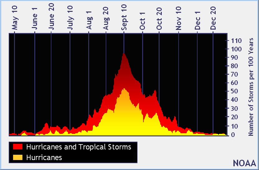
The Atlantic Hurricane Season runs through to the end of November. However, the traditional peak of the season is around September 10. While it’s inevitable that Paulette will form this season, it is also likely that storms behind it will form too; beyond Paulette, the remaining names on the list include Rene and Sally. Should any of these systems form soon, they would shatter records for the earliest “P”, “R”, and “S” storms on record in the basin. Currently, the earliest “P” storm on record was 2005’s Philippe which formed on September 17 of that year; the earliest “R” storm was Rita which formed on September 18 of the same year; the earliest “S” storm on record was Stan which also formed in a busy 2005 on October 2.
