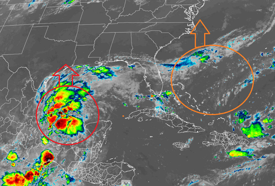
Two tropical cyclone threats appear to be growing today; one is in the Gulf of Mexico, the other is off the U.S. southeast coast. In time, Texas and the Mid Atlantic or Northeast coasts could be impacted by these disturbances.
The system in the Gulf of Mexico quickly developed into Tropical Storm Nicholas this morning. In the latest advisory from the National Hurricane Center (NHC), Nicholas is located about 130 miles northeast of Veracruz, Mexico and roughly 405 miles south-southeast of the mouth of the Rio Grande River. Maximum sustained winds are 40 mph while the minimum central pressure is around 29.77″ or 1008 mb.
With Nicholas approaching the Gulf coast, various warnings have been issued. The NHC has issued a Tropical Storm Warning for the coast of Texas from the mouth of the Rio Grande to Port Aransas. The Mexican Government has also issued a Tropical Storm Warning from Barra el Mezquital north to the U.S./Mexico border. The NHC also has a Storm Surge Watch for the Texas coast from the mouth of the Rio Grande to High Island. Also, the NHC has a Tropical Storm Watch up for the coast of Texas from north of Port Aransas to High Island. A Tropical Storm Warning means that tropical storm conditions are expected somewhere within the warning area within 36 hours. A Storm Surge Watch means there is a possibility of life-threatening inundation, from rising water moving inland from the coastline. A Tropical Storm Watch means that tropical storm conditions are possible within the watch area, generally within 48 hours.
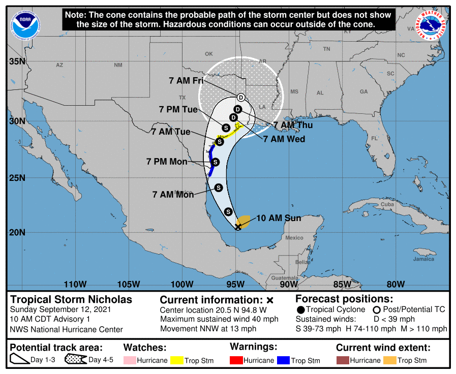
Nicholas is moving toward the north-northwest near 13 mph and this general motion is forecast to continue through tonight. According to the NHC, a slower northward or north-northeastward motion is forecast by late Monday or Monday night. On the forecast track, the center of Nicholas will pass near or just offshore the the coasts of northeastern Mexico and South Texas late Monday, and approach the south or central Texas coast Monday night or early Tuesday.
According to the NHC, data from an Air Force Reserve reconnaissance aircraft indicate that the maximum sustained winds are near 40 mph with higher gusts; gradual strengthening is forecast while Nicholas approaches the northwestern Gulf coast during the next day or so.
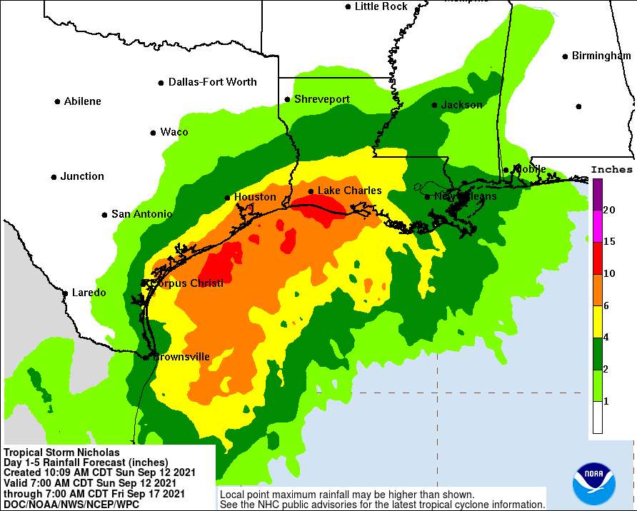
Even if Nicholas doesn’t grow into a hurricane, it will dump extremely heavy rain across portions of the Gulf Coast. 5-10″ of rain is likely, with isolated maximum amounts of 15″ possible too across portions of coastal Texas into southwest Louisiana today through the middle of the week. This rainfall may produce areas of flash, urban, and isolated river flooding.
The combination of a dangerous storm surge and the tide will cause normally dry areas near the coast to be flooded by rising waters moving inland from the shoreline. If the peak surge occurs at the time of high tide, a 2-4′ storm surge is possible across the Texas Gulf Coast including Galveston Bay. The deepest water will occur along the immediate coast in areas of onshore flow, where the surge will be accompanied by large and dangerous waves. Surge-related flooding depends on the relative timing of the surge and the tidal cycle, and can vary greatly over short distances.
While the NHC monitors Nicholas, they are also monitoring an area off the U.S. southeast coast. Some computer forecast guidance has been very bullish with developing a system here and driving it into portions of the Mid Atlantic and Northeast coasts. According to the NHC’s latest Tropical Outlook, an area of low pressure is expected to form north of the southeastern or central Bahamas in a few days resulting from a tropical wave interacting with an upper-level trough. Gradual development of this system is possible, and a tropical depression could form later this week several hundred miles southeast of the Carolinas while it moves northwestward across the western Atlantic. Because the Mid Atlantic and Northeast have been hit hard in recent weeks by what was left of Hurricanes Henri and Ida, people there should pay close attention to this developing system in the coming days. While the NHC says it is unlikely a tropical cyclone will form in the next 48 hours, those odds increase to 50% over the next 5 days.
