The 16th Tropical Depression of the 2016 Atlantic Hurricane Center has formed, and the National Hurricane Center brings it to Tropical Storm and Hurricane strength in the coming days.
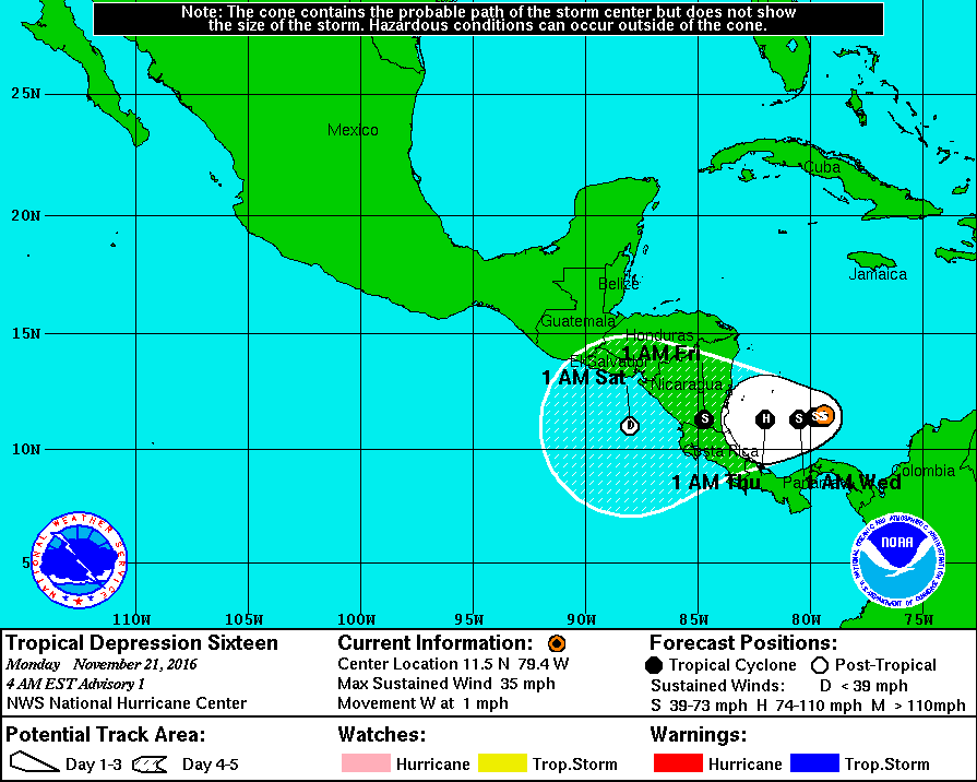
The cloud pattern associated with the low pressure system located over the southwestern Caribbean Sea has become better organized over the past 12 hours, including the development of some banding features. An Air Force Reserve reconnaissance aircraft yesterday indicated that the low had a well-defined circulation center, along with flight-level winds of 38 kt and SFMR surface winds of 32-34 kt in no-rain areas. Since that time, an intense convective burst with cloud tops of -88C developed near the center , which likely helped to spin up the inner-core circulation a little more. In addition, a ship located 90-100 nmi southeast of the center has been reporting winds as high 38 kt at an elevation of 34 meters, which adjusts to a 10-meter wind of 30-32 kt. Although cloud tops have warmed since that earlier strong convective burst occurred, the overall convective cloud pattern has improved since the recon flight yesterday.
The depression has been meandering in the same general area for the past 12 hours or so, and little motion is expected today and early Tuesday while the cyclone remains trapped within a blocking ridge pattern. By 36-48 hours, an east-west oriented ridge is forecast by the global models to develop across the Greater Antilles and the Bahamas, which is expected to nudge the depression in a slow westward direction for the remainder of the forecast period, with landfall possibly occurring after 72 hours. The system is expected to move across Central America and into the eastern North Pacific by 120 hours as a remnant low.

Marginal environmental conditions are only expected to support slow strengthening for the next 36 hours or so. After that, the moderate vertical wind shear currently affecting the cyclone is forecast to decrease to less than 10 kt while mid-level humidity values increase to more than 70 percent. This should allow for the depression to strengthen into a hurricane by 72 hours before landfall occurs. By 96 hours, the cyclone is expected to be inland over Central America and undergoing rapid weakening due to the interaction with the mountainous terrain of that region.
Visit our Tropical Weather Page here for further information about this system and a review of all tropical cyclones that were near US waters for the 2016 season: https://weatherboy.com/hurricanes-tropical-weather/
