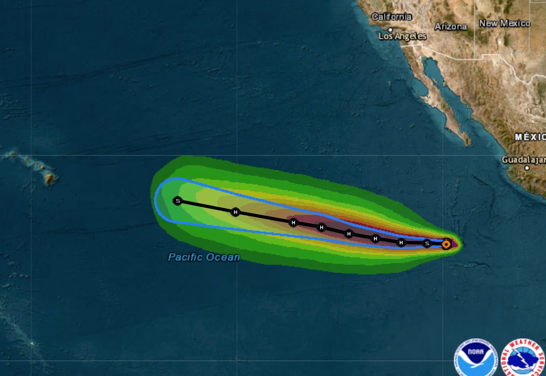
The National Hurricane Center (NHC) in Miami, Florida is issuing advisories on Tropical Storm Calvin, centered around 2,850 miles east-southeast of Hilo, Hawaii. Calvin is expected to move into the Central Pacific Hurricane Center (CPHC) area of responsibility Sunday night. Calvin may bring direct or indirect impacts to the islands of Hawaii later next week. With a possible storm threat on the horizon, people in Hawaii are being advised to make sure they’re ready for hurricane season.
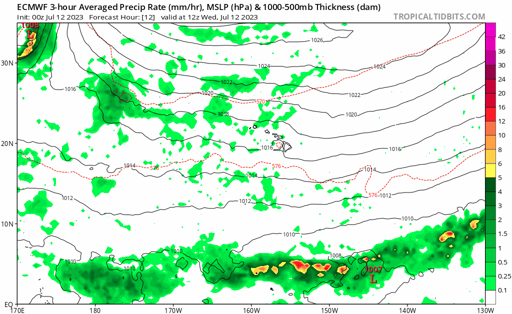
According to the NHC, Tropical Storm Calvin continues to strengthen today with increased curved banding beginning to wrap around the center, as well as cold cloud tops associated with a developing central dense overcast. Microwave satellite from this morning also showed the overall structure of the system is becoming better defined, with a prominent curved band beginning to wrap around the center of the storm. Given the improved structure based on recent satellite trends, the NHC boosted the intensity of the storm in its latest advisory.
The NHC says that the storm is currently in a conducive environment for strengthening, with light-to-moderate vertical wind shear, and warm sea surface temperatures. Given the environment, steady strengthening is predicted, with Calvin now forecast to become a hurricane in 24 hours.
Right now, with maximum sustained winds of 50 mph, Tropical Storm Calvin is moving west at 16 mph; its minimum central pressure is estimated to be 1002 mb or 29.59″. According to the NHC, a strong ridge located to the north of Calvin, over Mexico, should steer the cyclone westward to west-northwestward over the next several days.
Beyond that, computer forecast models used by meteorologists to aid with their forecasting suggest Calvin could strike or come close to Hawaii, with the Big Island of Hawaii the first in line for possible impacts. It is still too soon to say with any degree of certainty if Calvin will impact Hawaii and how severe any such impacts would be.
Hurricane Specialist Jon Jelsema with the Central Pacific Hurricane Center wrote in the latest Forecast Discussion, “The trades could potentially get really windy next Tuesday as the tropical cyclone Calvin or its remnant low nears the island chain.” Before the storm approaches, subsidence in advance of tropical cyclone Calvin could lower shower coverage on Monday into Tuesday. Should Calvin head to Hawaii, wet weather would arrive around the middle or later part of next week.
The Central Pacific Hurricane Season, like the Atlantic Hurricane Season, starts on June 1 and runs through the end of November.
Before the season began, NOAA’s Central Pacific Hurricane Center and NOAA’s Climate Prediction Center announced that conditions are prime for an above-normal season in the months ahead. Specifically, they said there’s a 50% chance of an above-normal season, a 25% chance of a near-normal season, and a 15% chance of a below-normal season. While forecasters include the expected number of tropical cyclones in the basin, they do not forecast where they will go once they form until they form. As such, some or none of these expected storms may make a rendezvous with Hawaii.
At the release of the seasonal forecast, Hawaii Governor Josh Green, M.D., said the people in the state should prepare prior to a threat for the season “Please, now that we’re in the season, have 14 days of water , have food available for you, know where you’ll go if there’s a storm and you’re asked to go to shelter in a safe place,” the Governor urged.
“The last few hurricane seasons have been pretty quiet around Hawaii, luring some folks to let their guard down. Now it’s looking like this season will be more active than the past several years,” said Chris Brenchley, director of NOAA’s Central Pacific Hurricane Center. “It’s more important than ever to review your emergency plan and supply kit now, so you will be prepared for the next hurricane threat.”
Talmadge Magno, the Administrator for Hawaii County Civil Defense, was present at the CPHC seasonal outlook unveiling in Honolulu in May too. He expressed concern with the forecast for Hawaii and his island. “I think the last 3 years, no matter what the numbers are, we always got to be prepared. Look what’s happening in Guam -it just takes one storm to create a disaster,” Magno said. Magno was referring to Typhoon Mawar which hit Guam in May, creating extensive damage throughout the U.S. territory. Mawar was one of the strongest typhoons to hit Guam in recent times.
Magno said being prepared is the best thing the people across Hawaii can do now. “The thing to take home this year is just be ready. Take this seriously. Have a plan; don’t just have a plan, but think it through.”
State, county, and federal officials are urging people in Hawaii and along the U.S. East and Gulf Coasts to have a Hurricane Action Plan in place before tropical cyclone threats arrive. According to the National Hurricane Center, knowing what actions to take before, during, and after a storm’s arrival can increase a person’s chance of survival.
