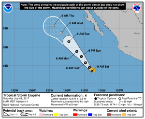
Tropical Storm Eugene is gaining strength in the Pacific today and is now forecast to become a hurricane by tomorrow morning. While no direct impacts on North America are expected, remnant moisture from this system could bring significant rains to portions of Mexico and the southwestern United States by later next week.
Eugene’s cloud pattern has improved significantly since yesterday; it now consists of a cyclonically-curved convective band wrapping around the center. The upper-level outflow continues to be very well established in all quadrants.
Eugene has the opportunity to gather some strength and become a hurricane during the next 24 hours or so. However, after that time, the National Hurricane Center believes a portion of the circulation will begin to reach cooler waters and drier air resulting in gradual weakening. By mid-week, the cyclone will be over much cooler waters and Eugene will probably lose most of its associated convection and become a remnant low.
While Eugene is picking up strength in the Pacific, the Atlantic Hurricane Basin is currently quiet with no tropical cyclones expected to form over the next five days. On Friday, Tropical Depression #4 degenerated and reformation is not expected.
Nevertheless, experts continue to call for a busy Atlantic hurricane season even though it appears to be quiet in the short term.