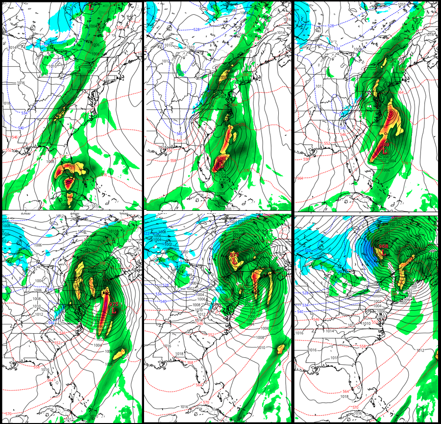
A very complex weather situation will unfold across the eastern United States tomorrow as Tropical Storm Philippe races north and becomes extra-tropical and merges with a frontal system. While the core of Philippe will race up and off the coast, the moisture and wind field will collapse into a single broad area of low pressure over the Mid Atlantic and move north into New England and southeastern Canada. As this transformation and merging takes place, wind-whipped heavy rains will blast the coast while heavy snow falls over portions of West Virginia.
While this storm arrives on the fifth anniversary of 2012’s Hurricane Sandy impact on the Jersey Shore and New York City metro area, and shares some characteristics with that complex storm system and weather pattern, what unfolds over the next 24 hours will be nothing like what happened with Sandy then. Nevertheless, people should prepare for a potent nor’easter that will produce a variety of dangerous weather conditions.
In the last advisory from the National Hurricane Center (NHC), the center of Tropical Storm Philippe was located by surface observations, radar data, and satellite images near latitude 23.0 North, longitude 82.6 West. Philippe is moving toward the north near 29 mph and this motion is expected to continue this evening, followed by a turn toward the northeast by early Sunday morning. A faster motion toward the northeast is expected on Sunday and continuing into Monday. On the forecast track, the center of Philippe will move off of the northern coast of Cuba and into the Straits of Florida this evening, and move across the Florida Keys or the southern tip of the Florida peninsula overnight, and across the northwestern Bahamas Sunday morning.
Inside Philippe, maximum sustained winds have increased to near 40 mph with higher gusts. According to the NHC, additional strengthening is forecast during the next 48 hours. Tropical-storm-force winds extend outward up to 105 miles mainly to the east and southeast of the center. A wind gust of 37 mph was recently reported at Key West International Airport. The estimated minimum central pressure based on surface observations is 1002 mb (29.59 inches).
As a tropical system, Philippe will bring many hazards across the Caribbean and Florida. 4-8″ of rain is expected across the Cayman Islands, western and central Cuba, and the northern Bahamas; some isolated amounts of 10″ could be possible here. In South Florida, including the Keys, 2-4″ of rain is expected with some isolated amounts to 6″ possible. These rain totals could produce flash flooding, especially in urbanized areas or in the Keys that are compromised by Hurricane Irma damage. Tropical Storm conditions underway in Cuba now will expand over southeast Florida tonight and the Bahamas tomorrow. Tornadoes are possible across portions of southern Florida including the Florida Keys tonight.
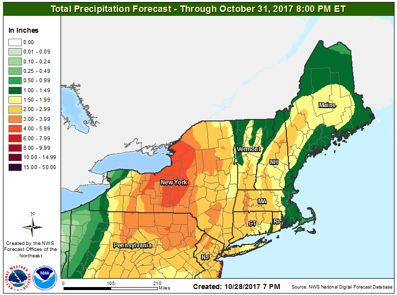
As the system begins extra-tropical transformation and merges with the frontal system, heavy precipitation and strong winds are likely across portions of the Mid Atlantic and New England. While Philippe won’t be a tropical cyclone when it nears the Mid Atlantic coast, tropical storm force wind gusts are possible well inland across New Jersey, eastern Pennsylvania, the New York City metro area, Long Island, and across a broad area of New England.
Heavy rain combined with strong winds could produce situations that promote the loss of power. Residents in the impacted region should be prepared for the possibility of power outages.

Just enough cold air will exist on the western fringe of this weather system to produce snow, heavy at times, over the higher terrain of West Virginia. There, 6″ or more of snow is possible on the highest peaks of West Virginia. Some flakes of snow may also fall in the highest terrain of western Pennsylvania and Maryland and western Virginia. Those planning travel through those higher areas should be prepared for heavy snow and the potential of white-out conditions from heavy snow and gusty winds.
The storm system will exit into eastern Canada on Monday, bringing an end to the wet and wild weather in the eastern United States. An approaching cold front will then push temperatures down to the coldest levels of the season by Tuesday night in the northeast.
