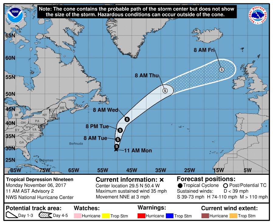
Overnight, the National Hurricane Center classified an area of disturbed weather in the central Atlantic Ocean as Tropical Depression #19; they now believe it will strengthen to a Tropical Storm and be named Rina. Fortunately, the storm should not directly threaten any landmass during its life cycle.
In the latest update from the National Hurricane Center, the center of Tropical Depression Nineteen was located near latitude 29.5 North, longitude 50.4 West. The depression is moving toward the north-northeast near 3 mph, and according to the official forecast from the National Hurricane Center, a significantly faster north to north-northeast motion is expected during the next couple of days. Maximum sustained winds are near 35 mph with higher gusts. The estimated minimum central pressure is 1013mb (29.92″.)
Although the environment ahead of the depression is not expected to be particularly conducive for strengthening as a tropical system, baroclinic enhancements and the expected faster forward speed should cause the cyclone to gain some strength during the next couple of days. In just the next 48 hours, slow strengthening is expected the
depression could become a tropical storm by tonight.
The global models agree that the cyclone should merge with a cold front by Wednesday evening, causing extratropical transition. The extratropical cyclone is expected to gradually weaken and dissipate in 4 to 5 days. While the official forecast map from the National Hurricane Center makes it look like this storm, as Rina, would impact Ireland and the United Kingdom like Ophelia did last month, this system is expected to be “washed-out” and weak by the time it nears Europe. As such, no serious impacts are expected from this system there.
There are just 3 weeks left of the 2017 Atlantic Hurricane Season, which ends on the last day of the month. It has been an exceptionally active one, with deadly and destructive Hurricanes Irma, Harvey, and Maria making a direct strike on the United States this season.