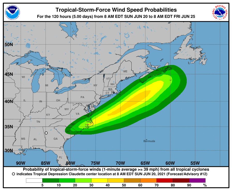
The National Hurricane Center (NHC) in Miami, Florida has issued Tropical Storm Warnings for portions of the North Carolina coast as Claudette heads for the southern Mid Atlantic. With Claudette, now a tropical depression, expected to strengthen back to tropical storm status as it approaches the Atlantic, Tropical Storm Warnings are up from Little River Inlet to Duck in North Carolina; Pamlico and Albermarle Sounds are also under a Tropical Storm Warning. A Tropical Storm Watch has also been issued for the area stretching from the South Santee River, South Carolina to Little River Inlet. A Tropical Storm Warning means that tropical storm conditions are expected somewhere within the warning area, in this case within 24 to 36 hours. A Tropical Storm Watch means that tropical storm conditions are possible within the watch area, in this case within the next 24 to 36 hours.
As of the latest NHC update, Claudette was moving toward the east-northeast near 17 mph with maximum sustained winds around 30 mph. An east-northeastward to northeastward motion with some increase in forward speed is expected over the next couple of days. On the forecast track from the NHC, the system should continue to move across portions of the southeastern U.S. through tonight, move over the coast of North Carolina into the western Atlantic Ocean on Monday, and pass near or just south of Nova Scotia on Tuesday.
The NHC says Claudette is forecast to become a tropical storm again late tonight or early Monday over eastern North Carolina. Further strengthening is possible over the western Atlantic Ocean through early Tuesday. However, Claudette is expected to become a post-tropical cyclone by late Tuesday.
Claudette is expected to produce additional rainfall totals of 2-4″ with isolated maximum totals of 6″ across the eastern portions of the Florida Panhandle into North Florida, southern Georgia, central and coastal South Carolina into eastern North Carolina through Monday morning. Flash, urban and small stream flooding impacts, as well as new and renewed minor river flooding are possible across these areas. Storm total rainfall of 5-10″ with isolated 15″ amounts were already observed in southeast Louisiana, southern Mississippi, southern Alabama, and the western Florida panhandle.
A storm surge is possible along the U.S. East Coast from Claudette. The combination of storm surge and the tide will cause normally dry areas near the coast to be flooded by rising waters moving inland from the shoreline. The water could reach 1-3′ from the North Carolina / Virginia Border to Cape Lookout, North Carolina if peak surge occurs at the time of high tide. A surge of 1-2′ is also possible from Cape Lookout to Little River Inlet in South Carolina. Surge-related flooding depends on the relative timing of the surge and the tidal cycle, and can vary greatly over short distances.
The NHC says tropical storm conditions are expected to begin in the warning area late tonight or early Monday. Tropical storm conditions are possible in the watch area tonight and Monday.
And as with any tropical cyclone over land, the NHC cautions that a few tornadoes are possible today across parts of Georgia and the Carolinas.
