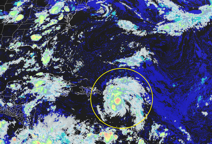
Tropical Storm Warnings are up for the tropical cyclone expected to become Tropical Storm Fred tonight; while no advisories are up for Florida yet, residents should be prepared there for likely impacts expected this weekend there. For now, the system is centered just south of the U.S. Virgin Islands, or about 105 miles southeast of Ponce, Puerto Rico, or about 310 miles east-southeast of Santo Domingo, Dominican Republic. With maximum sustained winds of 35 mph and barometric pressure of 1012 mb or 29.89″, the system is moving to the west-northwest at 17 mph.
As of the 5pm advisory from the National Hurricane Center, a Tropical Storm Warning is in effect for Puerto Rico, including Culebra and Vieques, the U.S. Virgin Islands, the Dominican Republic on the south coast from Punta Palenque eastward and on the north coast from Cabo Frances Viejo eastward. A Tropical Storm Warning means that tropical storm conditions are expected within the warning area within 36 hours.
A Tropical Storm Watch is in effect for the Dominican Republic on the north coast from Cabo Frances Viejo to the Dominican Republic/Haiti border, for Haiti from the northern border with the Dominican Republic to Gonaives, the Turks and Caicos Islands, and the Southeastern Bahamas. A Tropical Storm Watch means that tropical storm conditions are
possible within the watch area.
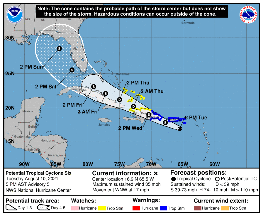
The National Hurricane Center expects gradual strengthening of this system, with the tropical cyclone forecast to become a tropical storm tonight. When the system becomes a tropical storm, it will be named Fred. On the forecast track, the disturbance is expected to pass near or over the U.S. Virgin Islands and Puerto Rico tonight, be near or over Hispaniola on Wednesday, and be near the southeastern Bahamas and the Turks and Caicos Islands on Thursday. Some weakening is likely while the system interacts with Hispaniola on Wednesday.
The future track and intensity of the storm will be dependent on what happens as it interacts with the Dominican Republic, Haiti, and Cuba. The more time the center of circulation spends over land, the more likely it won’t pick up additional strength. The more time it spends over water, the more likely it is to gain strength. The National Hurricane Center currently believes the storm will stay off-shore the north coast of Cuba, pegging the intensity at tropical storm strength as it impacts the Florida Keys late Friday / early Saturday. From there, the National Hurricane Center has the storm in the eastern Gulf of Mexico along the west coast of Florida for the weekend.
The system will bring heavy rain, gusty winds, and rough surf to the Caribbean. Over the Leeward Islands, Virgin Islands, Puerto Rico, and the Dominican Republic, 2-4″ with isolated maximum totals of 6″ are possible. Heavy rainfall could lead to flash, urban, and small stream flooding, along with possible rapid river rises and the potential for mudslides across the region. Tropical storm force wind conditions are expected in the warning areas in the U.S. Virgin Islands and Puerto Rico during the next several hours, and in the warning area in the Dominican Republic by early Wednesday. Tropical storm conditions are possible elsewhere along the northern coasts of the Dominican Republic, northern Haiti, the Turks and Caicos, and the southeastern Bahamas beginning late Wednesday. Swells generated by the disturbance are affecting portions of the Leeward Islands. These swells are expected to spread across the U.S. Virgin Islands and Puerto Rico today and reach portions of Hispaniola on Wednesday, where they could cause life-threatening surf and rip current conditions.
