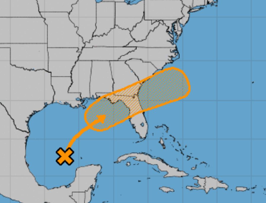
Tropical trouble appears to be brewing in the Gulf of Mexico and there could be impacts to the U.S. East Coast in time from whatever develops. The National Hurricane Center (NHC) has been tracking this area of disturbed weather for many days and now believes there’s a medium chance that a tropical cyclone will form.
According to the NHC’s latest Tropical Outlook, showers and thunderstorms have increased today over the south central Gulf of Mexico in association with a surface trough and an upper-level disturbance. The system is expected to move slowly northeastward over the central and northeastern Gulf of Mexico during the next couple of days.
For now, upper-level winds are currently unfavorable for development, but they are forecast by the NHC to become more conducive for some limited tropical or subtropical cyclone development as the system nears the northern Gulf coast on Wednesday and Wednesday night. According to the NHC, the disturbance is then expected to cross the southeastern United States, and some slight additional development will be possible after it emerges off the southeastern United States coast late this week. The NHC believes there’s a 30% chance of tropical cyclone formation over the next 48 hours and a 40% chance of tropical cyclone development over the next 5 days.
Regardless of development, areas of heavy rainfall will be possible across portions of the Florida panhandle and southern Georgia on Wednesday and Thursday, with localized flooding possible.
It is still too soon to know where this system would go beyond Thursday; the future track will be dependent on whether or not a tropical or subtropical cyclone actually develops and how the rest of the environment around the system resolves itself around it. It is within the realm of possibilities that the system could head up the East Coast, bringing another round of soaking rains to an area hit hard by what was left of hurricanes Henri and Ida. It is just as possible that the system could track north and east out to sea, bypassing most of the U.S. East Coast beyond the southeast coast. Because of these possibilities and the inability to rule anything out, residents of the entire U.S. East Coast should track the evolution of this system throughout the week.