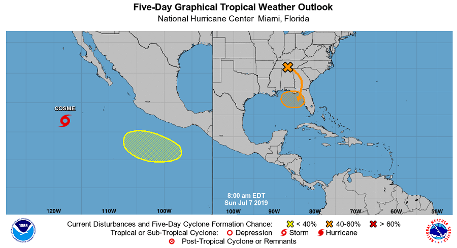
After a very quiet June, the tropics are perking up with multiple tropical cyclone threat possibilities in both the Atlantic and the Pacific. The remnants of Hurricane Barbara are headed to Hawaii while Tropical Storm Cosme spins about in the Eastern Pacific. Meanwhile, a disturbance located near Tennessee is forecast to head to the Gulf Coast, where it could organize into a tropical cyclone there.
High surf advisories are up for all of Hawaii while the Big Island of Hawaii is under a Flood Watch in anticipation of the arrival of Hurricane Barbara’s remnants. Moisture associated with the remnants of Barbara will move over the Big Island tonight, and then remain in place through Monday night before diminishing. With the moisture moving in from the east, the initial threat of heavy rainfall will be over windward areas, spreading to leeward areas on Monday. A Flash Flood Watch means that conditions are favorable for life-threatening flash flooding; the watch is in effect for Hawaii County through late Monday night.
Near where Barbara formed, a new storm is spinning about: Cosme. Unlike Barbara, Cosme is expected to weaken today and degenerate into a tropical depression by tonight; no hurricane intensification is expected. The storm should fade away in the Pacific and pose no direct threats to Hawaii or the U.S. and Mexican west coast.
A new system is forming not far from where Barbara and Cosme formed. According to the National Hurricane Center, an area of low pressure is expected to form several hundred miles south of the southern coast of Mexico in a few days. Some slow development is possible thereafter while the system moves westward to west-northwestward. While the National Hurricane Center (NHC) believes there’s no chance of formation in the next 48 hours, they believe there is a slight (20%) chance of formation here over the next 5 days.
The next system worthy of a watchful eye is over the southeastern United States. The NHC believes there are now better odds of this system forming than they thought last night. A trough of low pressure over the southeastern United States is forecast to move southward toward the northeastern Gulf of Mexico, where a broad low pressure area will likely form in a few days. Thereafter, upper-level winds support some development of this system while it meanders near the northeastern Gulf of Mexico coast through Friday. The NHC says development is unlikely over the next 48 hours, but now pegs a 40% chance of tropical cyclone formation over the next 5 days. Regardless of whether or not a tropical cyclone forms here, very heavy rain associated with that system could impact portions of the Gulf and East coasts in the coming days , especially beyond the end of this work week.