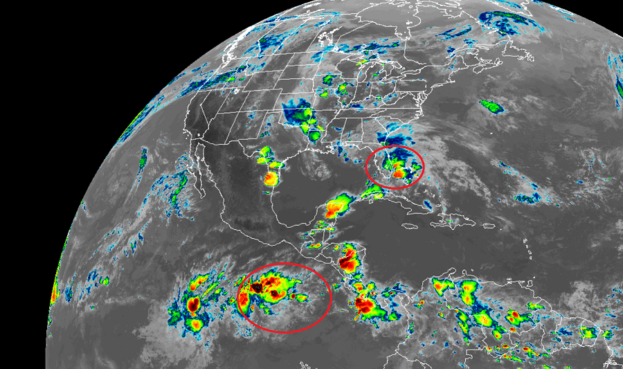
Activity in both the Eastern Pacific and Atlantic Hurricane Basins have perked up a bit on this Memorial Day. Meteorologists at the National Hurricane Center are monitoring two areas for potential development; one is around southern Florida, the other is south of Guatemala.
The system west of Central America appears to be more likely to develop into a tropical cyclone over time. According to the National Hurricane Center in Miami, Florida, a broad area of low pressure is expected to form in a few days south of the coasts of southern Mexico, Guatemala, and El Salvador. Environmental conditions appear conducive for gradual development of this system, and a tropical depression could form late this week or this weekend while it moves little or drifts northward. While the National Hurricane Center doesn’t believe any development will occur here over the next 48 hours, they believe there is a 60% chance that something will form over the next five days.
An area bringing much needed rain to Florida is also being monitored for development; however, for now, the National Hurricane Center believes there’s little chance that a tropical cyclone will form here. Widespread showers and thunderstorms extending across Florida, the Bahamas, and the adjacent Atlantic and Gulf of Mexico waters today are associated with an elongated surface trough interacting with an upper-level disturbance. Although a weak surface low could form along the surface trough just off the east coast of Florida and move northward toward Georgia and South Carolina on Tuesday and Wednesday, the National Hurricane Center currently does not expect the low to become a tropical cyclone due to strong upper-level winds. As such, the National Hurricane Center puts odds of any tropical development here at only 20%.
While tropical development isn’t expected, flooding rains could continue to occur over portions of southern and central Florida tonight, spreading northward to coastal sections of northeastern Florida, Georgia, and the Carolinas on Tuesday and Wednesday. Gusty winds could also produce rough marine conditions and life-threatening surf and rip currents along the coasts of eastern Florida, Georgia, and the Carolinas through Wednesday. People in these areas, especially in coastal communities, should be ready for such hazardous conditions that could occur even if tropical development doesn’t.
