While the calendar says it’s autumn, it’ll be looking and feeling a lot like winter for many with the first widespread snowfall expected this week in portions of the Northeast and Mid Atlantic. Two robust areas of low pressure will slide along the coast, bringing wind-whipped precipitation to the region. With the first helping to funnel colder air into the region ahead of the second, the second system could feature more snow across a wider area than the first.
The first system will slide into the northeast on Tuesday. Rain will spread up the coastal plain during the day Tuesday, becoming heavy at times near the coast. With relatively mild air in place, most precipitation from this storm will fall as plain rain. However, in interior northern New England, where temperatures will be just cold enough for snow, light to moderate snowfall accumulations are expected there. As the system moves up the coast, the pressure gradient will tighten across the Mid Atlantic , leading to gusty winds. Northwest wind gusts of 20-30 mph are expected across eastern Maryland, Virginia, Pennsylvania, New Jersey, and Delaware. The gusty winds will spread into Connecticut, New York, Rhode Island, Massachusetts, New Hampshire, and Maine late Tuesday into Wednesday.
On Wednesday, high pressure will allow for dry conditions to temporarily arrive along the East Coast. This high and the departing low will also help direct colder air into the Mid Atlantic, setting the stage for trouble on Thursday.
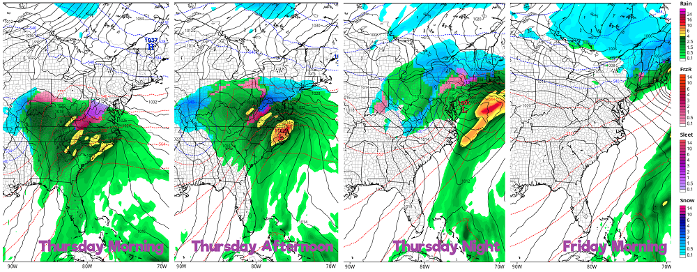
On Thursday and Friday, a winter storm will take shape. An upper low positioned across the ArkLaTex region Wednesday will get picked up and ejected northeastward across the Ohio Valley by another upper trough digging southward through Friday. This will result in another area of low pressure developing and moving up the East Coast late Thursday through Friday. With the colder air that will be in place in the wake of the early week system and high pressure anchored initially across New England, snow and sleet is looking more likely at the onset of this event across interior New Jersey, northern Delaware, Connecticut, upstate New York and New York City, central and western Maryland, Pennsylvania, and western Virginia. However, as the storm moves up through the day Thursday into Thursday evening, milder air from the ocean will help push the marginally cool temperatures above freezing at critical snow-creating layers of the atmosphere, resulting in a change to sleet and plain rain. This change-over to rain will occur in areas first seeing snow in Virginia, central and eastern Maryland, Delaware, New Jersey, eastern Pennsylvania, southeastern Upstate New York and New York City, Connecticut, Rhode Island, and southern Massachusetts. The rain/snow line could even push up into southern Vermont or New Hampshire by Friday morning before precipitation tapers off to light rain and snow showers there on Friday.
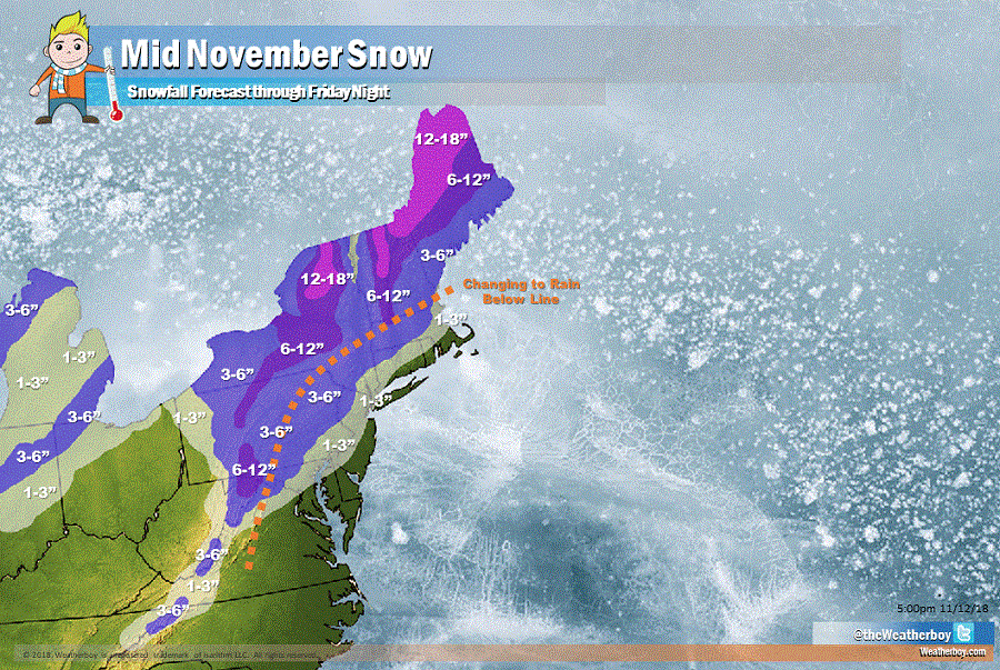
In places where cold air will stay locked-in for both systems, snow will accumulate and could accumulate to heavy levels. More than a foot of snow is possible across northern New York state, the highest elevations of Vermont and New Hampshire, and northern and western Maine. Lighter amounts will accumulate as you head south and east. And while snow is expected in Philadelphia and New York City and along the I-95 corridor early Thursday, we do expect a changeover to plain rain in this area which would turn any accumulations into slush and/or wash them away before the second storm wraps up on Friday.
On Friday night, high pressure will begin building from the west, bringing in cool, dry air into the northeast from Canada. While some scattered light showers or flurries are possible in the northeast again late Saturday, no more significant precipitation is expected through the weekend. Temperatures should remain at or slightly below normal in this area through the start of the new week next week.
