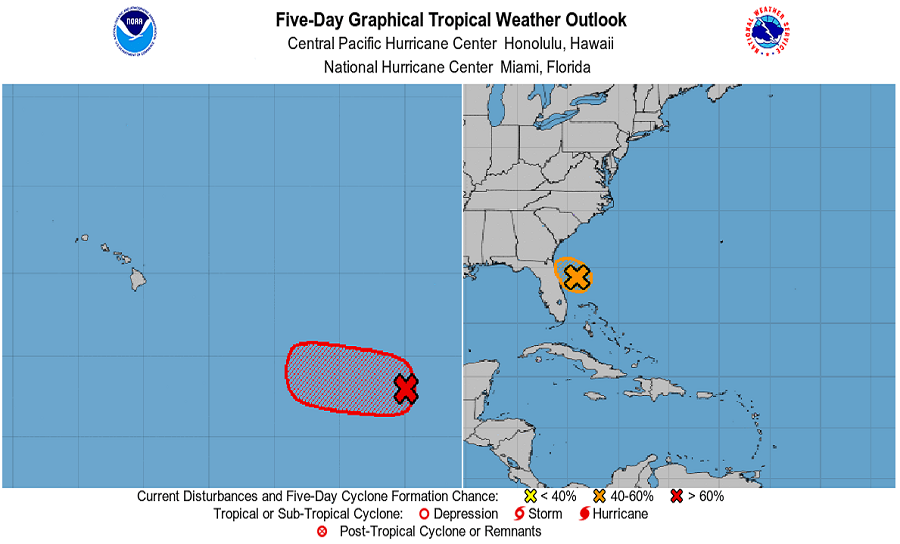
The National Hurricane Center (NHC) in Miami, Florida and the Central Pacific Hurricane Center (CPHC) in Honolulu, Hawaii are monitoring disturbances in the Atlantic and Pacific that could become tropical cyclones with time. While both systems are being tracked and reported on by the Miami-based unit, as a disturbance approaches Hawaiian waters, the Pacific system will be tracked and reported on by the Honolulu based crew starting tomorrow.
The system closest to the U.S. today is off the Florida coast. An area of low pressure is located about 150 miles east of Daytona Beach, Florida; it is producing disorganized shower and thunderstorm activity mainly over the southern part of its circulation. During an Air Force Reserve reconnaissance craft into the system by skilled Hurricane Hunters yesterday, a solid circulation was found. However, much of the convective activity was displaced far from the center, which would inhibit development. Preliminary reports from an Air Force Reserve reconnaissance aircraft today indicate that this system has changed little in strength since yesterday. The National Hurricane Center says environmental conditions are marginally conducive for development and a tropical depression could still form later today or early Monday while the low drifts westward or west-northwestward toward the northeast coast of Florida. Even if the storm doesn’t develop into a tropical cyclone, of which the NHC gives 50-50 chances of happening, soaking downpours are likely over Florida from this disturbance.
While the Atlantic system is struggling to take shape, it appears the system in the Pacific will become a tropical cyclone soon. Recent satellite and microwave imagery indicate that an area of low pressure located over 1,300 miles east-southeast of the Hawaiian Islands continues to show signs of organization. According to the NHC, environmental conditions remain conducive for further development, and a tropical depression is likely to form within the next day or so while the system moves westward at 10 to 15 mph. By tomorrow morning, this disturbance is expected to cross into the Central Pacific Hurricane Center’s domain; as such, advisories and forecasts for it will be issued by the Honolulu team rather than the Miami team from that point forward. Right now, the NHC believes there’s a 70% chance that this will develop into a tropical cyclone as it inches closer to Hawaii.
Elsewhere the tropics are quiet. The NHC says an area of low pressure is forecast to develop by midweek a few hundred miles south or southeast of the Gulf of Tehuantepec on the south coast of Mexico. It should remain several hundred miles offshore of the coast of Mexico this week even if it does develop. Beyond the threat of development there, the NHC doesn’t expect any tropical cyclone to develop anywhere around U.S. waters for the next five days.