With the recent and ongoing volcanic activity in Iceland, St. Vincent (Caribbean), Mexico, Alaska, and Hawaii, along with seismic activity in both the Pacific and Atlantic basins, authorities want people to be prepared along the coasts for tsunamis even though there is no imminent threat from one at this time. Tsunamis can occur anywhere along the Pacific and Atlantic coasts; they aren’t an exclusive phenomenon to Alaska, Hawaii, and the U.S. West Coast.
In time for Tsunami Awareness Week in California, the California Geological Survey (CGS) released new inundation maps reflecting how far inland a surge of seawater could go in a worst-case scenario. Updating maps that were last drawn up in 2009, the maps also tie a small buffer beyond the modeled inundation area to landmarks or roads to help emergency managers and local officials best communicate evacuation plans.
“After 10 years of research following the Tohoku-Oki earthquake and tsunami in Japan, we’re releasing maps with many improvements to keep Californians safe,” said Dr. Steve Bohlen, Acting State Geologist of California and head of CGS. “Japan utilized data from several hundred years of tsunami records in its planning, which seemed perfectly reasonable, then was hit by a once-a-millennium tsunami. So, we’re using a thousand-year scenario as the baseline for our new maps, hoping to avoid the tragic loss of life experienced there. While damaging tsunamis are infrequent in California, if you’re on the coast, you need to be aware of this potential hazard.”
According to the CGS, California has been hit by more than 150 tsunamis since 1800. While most were barely noticeable, a few have caused fatalities or significant damage. As an example, the 2011 Japan Tsunami caused $100 million of damage to California ports and harbors. The most destructive tsunami to hit California occurred March 28, 1964. Several surges reaching 21 feet high swept into Crescent City four hours after a magnitude 9.2 earthquake in Alaska, killing 12 and leveling much of the town’s business district.
While the new Los Angeles County map takes a variety of potential tsunami sources into account, the worst-case scenario would result from a magnitude 9.3 earthquake in the eastern Aleutian Islands.
Hawaii is also urging its residents to prepare for tsunamis and has declared April as Tsunami Awareness Month. April was chosen as Tsunami Awareness Month to honor and remember the lives lost in all tsunamis that have hit the state over the years.
One of the deadliest tsunamis to ever hit Hawaii hit in April of 1946 and different events to mark the 75th anniversary of that devastating natural disaster continue to be held in the Aloha State this month. The 1946 event created widespread devastation on all islands, ultimately claiming 159 lives and costing more than $26 million in damage.
Like California, Hawaii was also hit hard by the 2011 Japan Tsunami. Extensive damage to private and public property occured in the counties of Honolulu, Maui, and Hawaii. According to the Hawaii Emergency Management Agency, more than 200 waves were recorded from that single event, creating more than $7.5 million in damage.
Because of Hawaii’s vulnerability of being in the middle of the Pacific Ocean in the middle of the seismically active “Ring of Fire”, Hawaii is one of the most prepared states in the nation for tsunamis. Hawaii became the first jurisdiction in the U.S. to implement evacuation maps for emergency response operations; Hawaii has also created the largest outdoor warning siren system in the U.S., with 410 installed across the state. Hawaii plans to upgrade 73 of those sirens and add an additional 76 to use new technology to ensure tsunami alerts are communicated to people in the event of a tsunami risk.
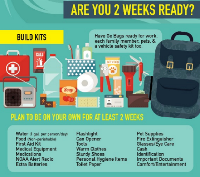
“We urge all residents and visitors to prepare for incidents that can occur with little warning any time of the year, day or night,” said Luke Meyers, Administor, for the Hawaii Emergency Management Agency (HI-EMA) in a Tsunami Awareness Month public service announcement. “You should also take this time to prepare yourself a go-bag that you can quickly take with you during an emergency situation. Be prepared before a tsunami strikes; learn the facts and help save lives.”
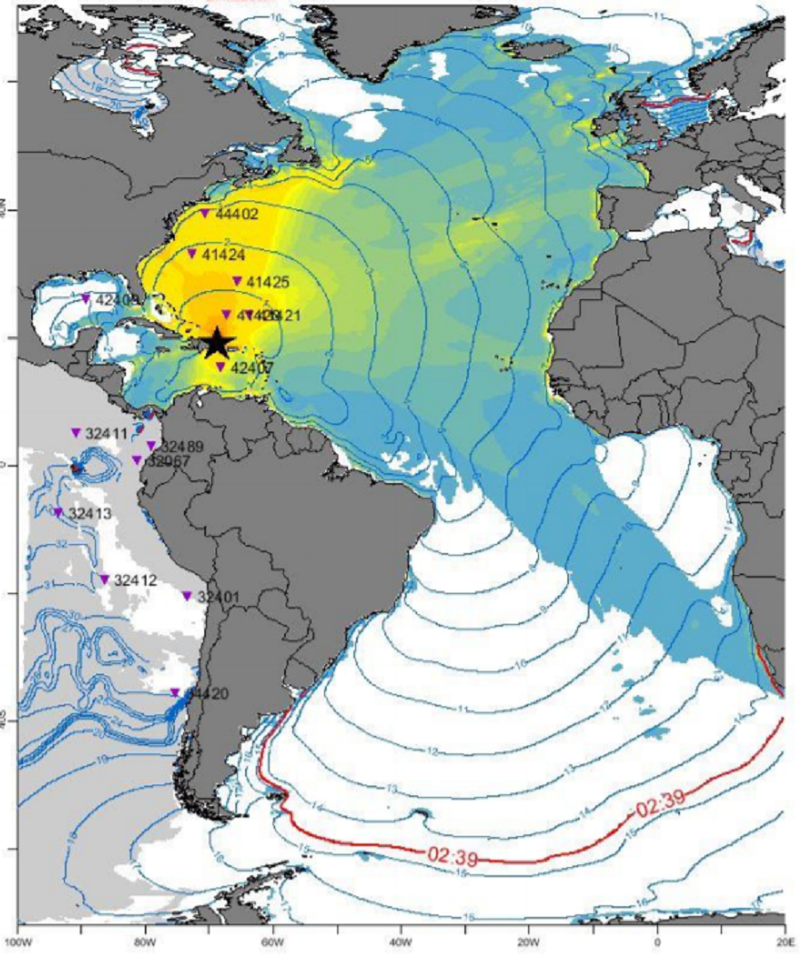
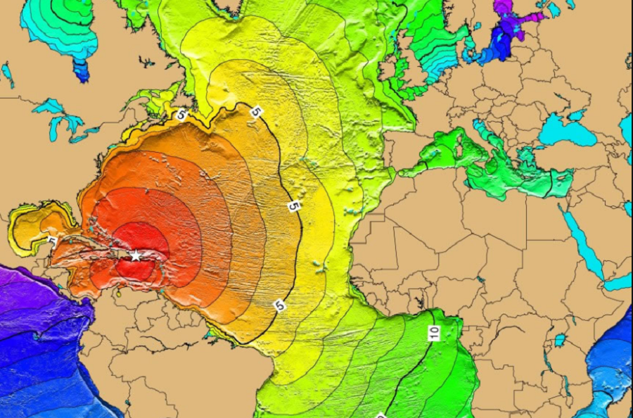
While not nearly as common as they are in the Pacific, tsunamis can and do occur from time to time in the Atlantic basin too.
To prepare for the possibility of major earthquakes around the North Atlantic and the possible tsunamis they could create, officials participated in earthquake and tsunami drills in March. On March 11, through the CaribeWave ’21 Tsunami Warning System Exercise, officials drilled for two hypothetical earthquakes and tsunami threats. Days later, on March 17, another large scale exercise was practiced. Unlike the CaribeWave ’21 event which focused on preparedness in the Caribbean, the March 17 LANTEX 21 drill was designed to prepare the rest of the North American Coast for tsunami dangers.
In addition to California and Hawaii, many states have prepared tsunami inundation maps along the U.S. West and East coasts. Different geological agencies, emergency management offices, and even educational institutions have developed these local maps. Mississippi on the Gulf Coast and Connecticut, Rhode Island, New Hampshire, and Maine on the East Coast do not currently have inundation maps prepared.
Alabama
Alaska
California
- Alameda
- Contra Costa
- Del Norte
- Humboldt
- Los Angeles Area
- Marin
- Mendocino
- Monterey
- Napa
- Orange
- San Diego
- San Francisco
- San Luis Obispo
- San Mateo
- Santa Barbara
- Santa Clara
- Santa Cruz
- Solano
- Sonoma
- Ventura
Delaware
Florida
- Anna Maria Island
- Destin
- East Gulf Breeze
- Englewood
- Key West
- Naples
- Navarre
- Okaloosa Island
- Osprey-Venice
- Panama City
- Pensacola, FL
- Sanibel Island
- Siesta Key
- Tampa Area – North
- Tampa Area – South
Georgia
Hawaii & Guam
Louisiana
Oregon
Maryland
Massachusetts
New Jersey
- Atlantic City Area
- Avalon
- Barnegat
- Cape May
- Long Beach Island
- Ocean City
- Perth Amboy
- Red Bank and Sandy Hook
- Seaside Heights
- Spring Lake
New York
- Bay Port
- Brooklyn
- East Hampton
- Fire Island
- Green Port
- Hampton Bays
- Huntington
- Jones Beach
- Long Beach
- Manhattan
- Montauk
- Port Jefferson
- Queens
- Shelter Island
- Southampton
- Staten Island
- Stony Brook
- Westhampton
North Carolina
Puerto Rico
South Carolina
Texas
- Freeport
- Galveston Area
- Jamaica Beach
- Port Aransas
- San Luis Pass
- South-East Corpus Christi
- South Padre Island
U.S. Virgin Islands
Virginia
Washington
- Statewide Interactive Guide
- Anacortes and Bellingham area
- Anacortes and Whidbey Island
- Bellingham
- Elliot Bay Area / Seattle
- Everett Area
- Neah Bay Area
- Port Angeles and Port Townsend
- Quileute Area
- San Juan Islands
- Southern Washington Cost / First Half
- Southern Washington Coast / Second Half
- Tacoma Area