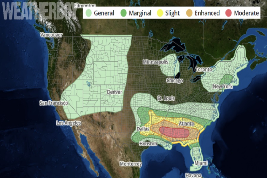
An unusually potent severe weather threat is set up for today in portions of the southeast; usually, such a weather pattern is more common in the early spring or late fall months, and not in mid/late June. Nevertheless, portions of northeastern Louisiana, central Mississippi and Alabama, and southwestern Georgia could see severe thunderstorms today with damaging wind gusts, large hail, and tornadoes.
According to the National Weather Service’s Storm Prediction Center (SPC), significant severe thunderstorms capable of producing all severe hazards, including very large hail, swaths of intense wind gusts and damage, and tornadoes, are possible across a broader area that includes much of the Lower Mississippi Valley and Southeast states today into tonight. “This scenario is largely attributable to seasonally very strong westerlies at these latitudes for mid-June, essentially record or near-record strength mid/high-level winds based on observed sounding climatologies,” wrote the SPC in their latest Convective Outlook for today’s expected severe weather event. “Mid-level lapse rates are also similarly rare in terms of seasonal steepness, as per 00z/12z observed soundings across the ArkLatex/Lower Mississippi Valley.”
Many hazards are possible today. They include very large hail, some greater than 3″ in diameter, swaths of intense wind gusts greater than 80 mph, and tornadoes, a few of which could be strong. The greatest potential for tornadoes is currently expected this afternoon/evening across the southern half of Alabama into southwest Georgia. The SPC says this area is where semi-discrete supercells are plausible initially near/south of outflow-related effective boundary, in the presence of considerably strengthening low-mid level winds today.
“Overall expectations are for multiple rounds of severe storms regionally today into tonight. Locations may see a mix of supercells and intense bowing segments during the day, with potential for a derecho to develop across the Lower Mississippi Valley,” warns the SPC.
There’s also a risk of some severe storms in portions of the northeast today; however, those storms will be less concentrated and less severe than what’s expected to develop in the southeast. In the northeast, modest air mass destabilization is expected ahead of an upper low. One or more north-south orientated bands of convection are expected as ascent attendant to this cyclone moves through. The SPC cautions, “Instability will be modest, mitigated by weak lapse rates, but a few stronger gusts and small hail are possible as these storms move east/northeast through the afternoon.” The best chance for such severe storms is over the northern half of New Jersey, the New York City metro area, eastern New York, and southeastern New England.
