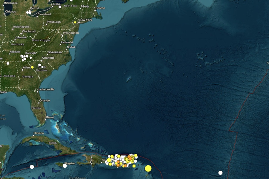
The USGS and other U.S. agencies like the National Tsunami Warning Center continue to monitor a surge of earthquakes occurring near Puerto Rico and nearby islands in the Atlantic basin; in the last 30 days alone, there have been 240 reported earthquakes there including one which generated a tsunami bulletin. While this is normally a seismically active area near a plate boundary, the increase in earthquake activity in the last 30 days has been notable.
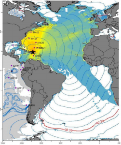
Of the 240 earthquakes to hit the area, the strongest earthquake struck on May 16 at 10:50 am Eastern Time; it was a magnitude 6.1 earthquake which struck near the Leeward Islands in the Caribbean Sea from a depth of 39 miles. Specifically, the epicenter was at 17.6 North and 61.0 West. Due to that quake, the National Weather Service National Tsunami Warning Center (NTWC) in Palmer, Alaska issued a Tsunami Information Statement for the U.S. East Coast, the Gulf of America States, and eastern Canada that said, “Based on earthquake information and historic tsunami records, the earthquake is not expected to generate a tsunami.”
Puerto Rico and the Dominican Republic sit on a complex tectonic boundary between the North American and Caribbean plates. The interaction of these plates, including subduction and strike-slip motion, contributes to the area’s seismic activity.

The most prominent fault zones in the area are the Great Northern and Great Southern Puerto Rico fault zones, which are considered largely quiescent but may be zones of weakness. Other notable fault lines include the South Lajas fault, Punta Montalva fault, Cerro Goden fault zone, and the Salinas fault, some of which have shown evidence of Quaternary activity. The southwest region of the island of Puerto Rico has been particularly active recently, with the 2019-2020 seismic sequence highlighting the potential for complex fault interactions.
The earthquakes in southwest Puerto Rico aren’t far from the epicenter of a strong earthquake that hit in January 2020. That 6.4 created extensive damage in Puerto Rico, including widespread power failures across much of the island. An earthquake swarm started there in December 2019 and unrest has continued since.
These earthquakes in southwest Puerto Rico are occurring near the northern edge of the Caribbean Plate, a mostly oceanic tectonic plate underlying Central America and the Caribbean Sea off of the north coast of South America. The Caribbean Plate borders the North American Plate, the South American Plate, the Nazca Plate, and the Cocos Plate. The borders of these plates are home to ongoing seismic activity, including frequent earthquakes, occasional tsunamis, and sometimes even volcanic eruptions.
While most people relate the threat of tsunamis to the Pacific, the Caribbean and the broader Atlantic basin can get them too.
Tsunamis are giant waves caused by earthquakes or volcanic eruptions under the sea. Out in the depths of the ocean, tsunami waves do not dramatically increase in height. But as the waves travel towards land, they build up to higher and higher heights as the depth of the ocean decreases. The speed of tsunami waves depends on ocean depth rather than the distance from the source of the wave. Tsunami waves may travel as fast as jet planes over deep waters, only slowing down when reaching shallow waters. While tsunamis are often referred to as tidal waves, this name is discouraged by oceanographers because tides have little to do with these giant waves.
The United States and other governments across the Atlantic and Caribbean participate in annual tsunami drills should one of these earthquakes trigger one. As an example, in the upcoming LANTEX ’26 tsunami drill, officials in the United States and Canada will rehearse a theoretical tsunami event. This tsunami exercise for 2026 is scheduled to take place on November 4, 2026 . This annual drill is designed to test the operational readiness of the Tsunami Warning System, coastal communication channels, and emergency response plans across the Atlantic seaboard.
These earthquake and tsunami drills will help bring awareness to the threats these areas could experience, allowing local officials and residents to be ready when an actual threat arrives.
Fortunately, as of this moment, the seismic activity around the Dominican Republic and Puerto Rico haven’t been strong enough to generate tsunamis. Should that change, the National Tsunami Warning Center and the Pacific Tsunami Warning Center would issue bulletins alerting the public of the threat.
