
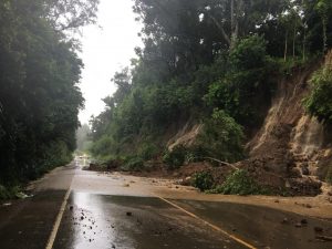
A storm system known as a “Kona Low” will bring very heavy snow, severe thunderstorms and flooding rains, and damaging winds to Hawaii this week, prompting the National Weather Service to issue a variety of advisories for the Aloha State.
The Kona Low gets its name from the change in wind direction that occurs when such a storm moves over the Hawaii Islands. Hawaii is dominated by the trade winds that typically blow in from the northeast. However, the counter-clockwise flow around a Kona low located west of Hawaii results in southwesterly winds over the islands, which is typically the leeward or “Kona” side. Kona Lows are most common between October and April. These type of storms draw abundant moisture up from the warm tropical waters that surround Hawaii; when this moist flow interacts with the steep topography of the island which helps to wring-out moisture, extremely heavy precipitation can fall. Because the wind flow around a Kona Low is atypical, flooding rains occur in places that may not ordinarily flood in tropical downpours that impact the islands from time to time.
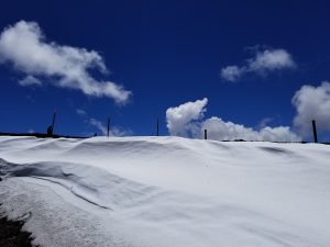
While most people don’t associate the tropical paradise Hawaii is known for with snow, they’re surprised to learn that it does snow in the winter due to the elevation of its volcanic peaks. Mauna Kea is the highest of the bunch at 13,803 feet. Maui’s Haleakala is much lower at 10,023 feet. Because of that difference, Hawaii Island will see snow more frequently than the lower peak of Maui Island. Just one storm in January 2020 dropped 2-3 feet of snow on Hawaii Island and created snow drifts that were far deeper. Another storm in 2021 brought snowboarders and skiers out to the mountain by the dozens.
This week, an especially powerful Kona Low is expected to impact the state this week and into the weekend, bringing numerous hazards across the islands. A combination of the potential for considerable flash flooding, damaging winds, and strong to severe thunderstorms will threaten the Aloha State from Tuesday through at least Saturday.
The risk for flash flooding could begin as early as Tuesday and Tuesday night over Kauai and Oahu as deep tropical moisture spreads into the western end of the state. Because of this threat, the National Weather Service in Honolulu on the island of Oahu has issued a Flood Watch for Kauai and Oahu islands.
This flood threat will expand eastward across the state by the latter half of the week, with the likelihood for severe thunderstorms increasing late this week and into the weekend.
Ahead of the rainfall, local officials are urging people to prepare. “Now would be a good time to clear storm drains, culverts, and other
drainage areas of debris to help reduce localized flooding.
The National Weather Service has issued a Special Weather Statement due to this severe weather threat. In a statement released this morning, the Honolulu-based meteorologists wrote, ” While flash flooding remains a major concern, confidence is increasing that strong to severe thunderstorms may develop Wednesday into the weekend. Damaging winds will likely be the primary hazard with these storms, though large hail cannot be ruled out.”
Deterministic models and their respective ensembles remain in strong agreement regarding the evolution of this system. At the surface, model guidance depicts a broad area of low pressure consolidating northwest of the islands in response to strong upper-level height falls. Central pressures could fall to near 990 mb while remaining well northwest of the state. The resulting pressure pattern will shift winds across the islands out of a southerly direction, drawing a plume of deep tropical moisture northward across the region.
According to the National Weather Service, the combination of strong upper-level forcing for ascent, deep tropical moisture, and persistent southerly flow will create a favorable environment for periods of heavy rainfall with embedded thunderstorms. Repeated rounds of convection may occur as smaller disturbances rotate through the broader upper trough, increasing the potential for training rainfall bands along terrain-favored areas.
Flooding concerns are expected to increase statewide as the week progresses, particularly where the heavier rainfall persists over the same areas for multiple days. By late week and next weekend, soils will already be saturated, increasing the likelihood that additional rainfall will produce rapid runoff and dangerous flooding conditions.
In addition to the rainfall threat, strengthening south to southwest winds may develop during the latter portion of the week and upcoming weekend as the pressure gradient tightens between the developing low to the northwest and high pressure to the east.
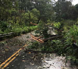
“If this materializes, strong and damaging Kona winds and localized downslope winds capable of downing trees and power lines will be likely,” warns the National Weather Service.
While thunderstorms are certainly possible earlier in the event, the environment will become increasingly favorable for severe
storms by midweek as as the thermodynamics and kinematics become more supportive.
While heavy rain and severe thunderstorms will lash all of the Hawaiian islands, the summits on the Big Island of Hawaii will see significant wintry precipitation. “For the summits of the Big Island, periods of heavy snow with significant accumulations will become possible later in the week through the weekend, likely requiring the issuance of a winter storm watch/warning,” the National Weather Service said.
The Big Island summits could also see hurricane-force wind gusts; sustained winds of 50-55 mph are likely with gusts of 75-85 mph; the greatest risk of high winds there will be Thursday night into Saturday morning.
While uncertainty remains regarding the exact timing and location of the heaviest rainfall and storms, confidence continues to increase that the islands will experience a prolonged period of unsettled and potentially impactful weather this week.
“Residents and interests across the state should continue to monitor forecasts as details regarding the timing and location of impacts become clearer,” cautions the National Weather Service.
