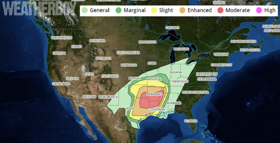
A potent storm system is producing a significant severe weather outbreak in portions of the southern states while the same system is helping surge record warmth up the U.S. east coast.
A very complicated and impactful forecast is in store for tonight as an unseasonably strong severe event unfolds. The greatest threat of severe weather today will be over northeastern Texas, northern Louisiana, southeastern Oklahoma, and southern Arkansas. Western Alabama is also at risk late tonight, with building risk there and over Alabama tomorrow. People in this region should be prepared to monitor for dangerous weather conditions tonight. Expectations are for a line of thunderstorms to enter the area from the west/northwest around 7 or 8pm, reach I-45 between 9pm and midnight, and continue to move east into Louisiana late tonight. While there is some potential for strong to severe storms to erupt with daytime heating late this afternoon here, the expectation is that the worst of the storms will hold off until tonight.
With these storms, the primary threat with this event is likely to be damaging winds. The strongest wind gusts could reach 75 mph according to the National Weather Service. Tornadoes will also be possible; tornadoes could be especially strong and follow long, destructive tracks. Finally, large hail is also a potential threat; some hail could become large enough to create substantial damage.
People in the risk area should make sure they can get, hear, and act on any severe weather warnings that may be issued during the overnight hours, especially if they’re sleeping. People may only have moments to act when a Tornado Warning is issued.
The same system helping drive severe weather east will help surge mild air north. Unseasonably mild weather will be experienced throughout the Mid Atlantic and southern New England this weekend. As an example, we expect Philadelphia’s record high of 66 tomorrow set in 1975 to fall with a new expected high temperature of 67; on Sunday, we expect Philly to tie its record high of 72 set in 1890. More high temperature records are likely to fall tomorrow and Sunday as this weather system moves through.