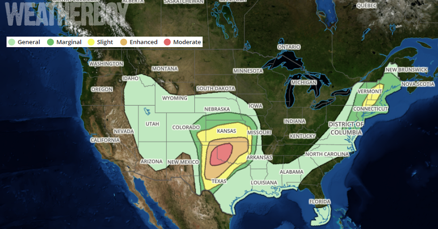
The National Weather Service’s Storm Prediction Center is warning people of a significant, violent weather outbreak that is expected tomorrow which will produce dangerous thunderstorms and strong tornadoes. The greatest threat of violent weather will be over portions of Kansas, Oklahoma, and Texas, with a bullseye of potentially deadly weather near the Texas/Oklahoma border.
According to the Storm Prediction Center, a “complicated yet potentially higher-end severe weather scenario will unfold across the southern Plains.” throughout the forecast period. Technically, height falls associated with an approaching longwave trough centered over Arizona will overlie a strong surface dryline along the New Mexico/Texas border, resulting in a north-south oriented band of storms in that area in the early morning hours. These storms will migrate northeastward and contain a threat for hail and damaging wind gusts throughout the morning due to steep mid-level lapse rates and supercellular wind profiles. The National Weather Service says a tornado threat may also exist on the southern end of this activity, especially where convection can become surface-based and remain discrete amidst with slightly higher boundary layer moisture.
The real action will hit during the afternoon. The evolution of this early morning weather complex will impact the severe risk in downstream areas of Oklahoma and northwest Texas through the afternoon and evening. A variety of computer forecast models suggest that the greatest risk of violent weather appears to be across portions of southwestern Oklahoma and vicinity. These storms are expected to reside in a environmental parameter space supportive of all severe hazards, including significant hail and strong tornadoes, and this risk should be maximized as long as discrete, cellular convection can persist through the forecast period. This risk will become further enhanced by an increasingly strong low-level jet across the region during the early evening should storms maintain a relatively discrete mode. This means multiple severe storms are expected to form, with some hitting the same area repeatedly. If a community is hit by a tornado, it doesn’t preclude it from being hit again in this severe weather event.
While the worst weather in the country will be in the midwest, there’s also an elevated chance of severe storms over the northeast. Surface heating ahead of an approaching cold front near the Appalachians will result in steepening low-level lapse rates and weak instability. Mid-level lapse rates will be relatively poor, although the glancing influence of an approaching wave over the eastern Great Lakes will result in development of a few convective cells along and ahead of the front. Strong flow aloft and downward transport of that momentum near storms will result in a few damaging wind gusts. This risk should wane with eastward extent as Monday night arrives. Until then, an area from just north of New York City north and east into Vermont and New Hampshire will see the best chances for severe weather.
