Just 10 days after a colorful rocket launch from the Mid Atlantic spaceport, NASA is preparing again for another launch at the NASA Wallops Flight Facility in eastern Virginia. This mission, scheduled for launch on May 26, is carrying a payload to understand radio waves in the upper layers of the Earth’s atmosphere.
Known as the Very low frequency trans-Ionospheric Propagation Experiment Rocket, or VIPER for short, the scientific payload is expected to be lifted up by a Terrier-Improved Malemite suborbital sounding rocket sometime at or after 9:15 pm Wednesday night. The launch window opens at 9:15 pm and runs through to midnight; the rocket could launch anytime during that window. If for whatever reason the rocket can’t launch, mission controllers will attempt a launch on back-up days of May 27 or May 28.
The 2-stage rocket will carry the VIPER payload up to about 94 miles before descending and landing in the Atlantic ocean. The rocket nor the payload will be recovered.
VIPER is studying very low frequency (VLF) radio waves and how such waves from Earth can interact with electronics in the Van Allen Radiation belts.
“At night, the lower layers of the ionosphere are much less dense, and more of the VLF can leak through, propagate along the Earth’s magnetic field lines, and end up interacting with the high energy electrons trapped in the Van Allen Radiation Belts,” said Dr. John Bonnell, the project’s principal investigator from the University of California, Berkeley.
“Those belts of intense energetic electron fluxes cover a range of distances from the Earth, from as close as 14,300 miles altitude (~4.4 Earth radii) out to 23,500 miles altitude (~7 Earth radii). GPS satellites orbit at around 4.4 Earth radii, and geosynchronous satellites at about 6.6 Earth radii. So, satellites in those orbits are often engulfed by the Van Allen Radiation Belts and have to tolerate the effects those energetic particles have on electronics and materials,” said Bonnell.
The VIPER mission will help take accurate measurements of VLF electromagnetic fields and the properties of the ionosphere below, at, and above the absorption and reflection layers in the Earth’s ionosphere.
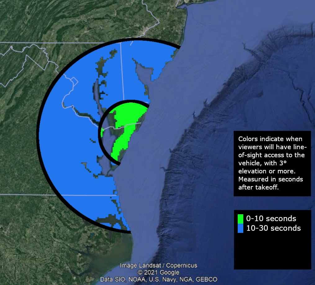
While the NASA Visitor Center at Wallops won’t be open for launch viewing, the spaceport does plan to provide live coverage of the mission from the Wallops IBM video site. People portions of southern New Jersey, Delaware, eastern Maryland and Virginia, and northeastern North Carolina may also be able to see the rocket launch simply by looking outside in skies free of light pollution and clouds.
